Agras T100 at High Altitude: What Field Capture Really
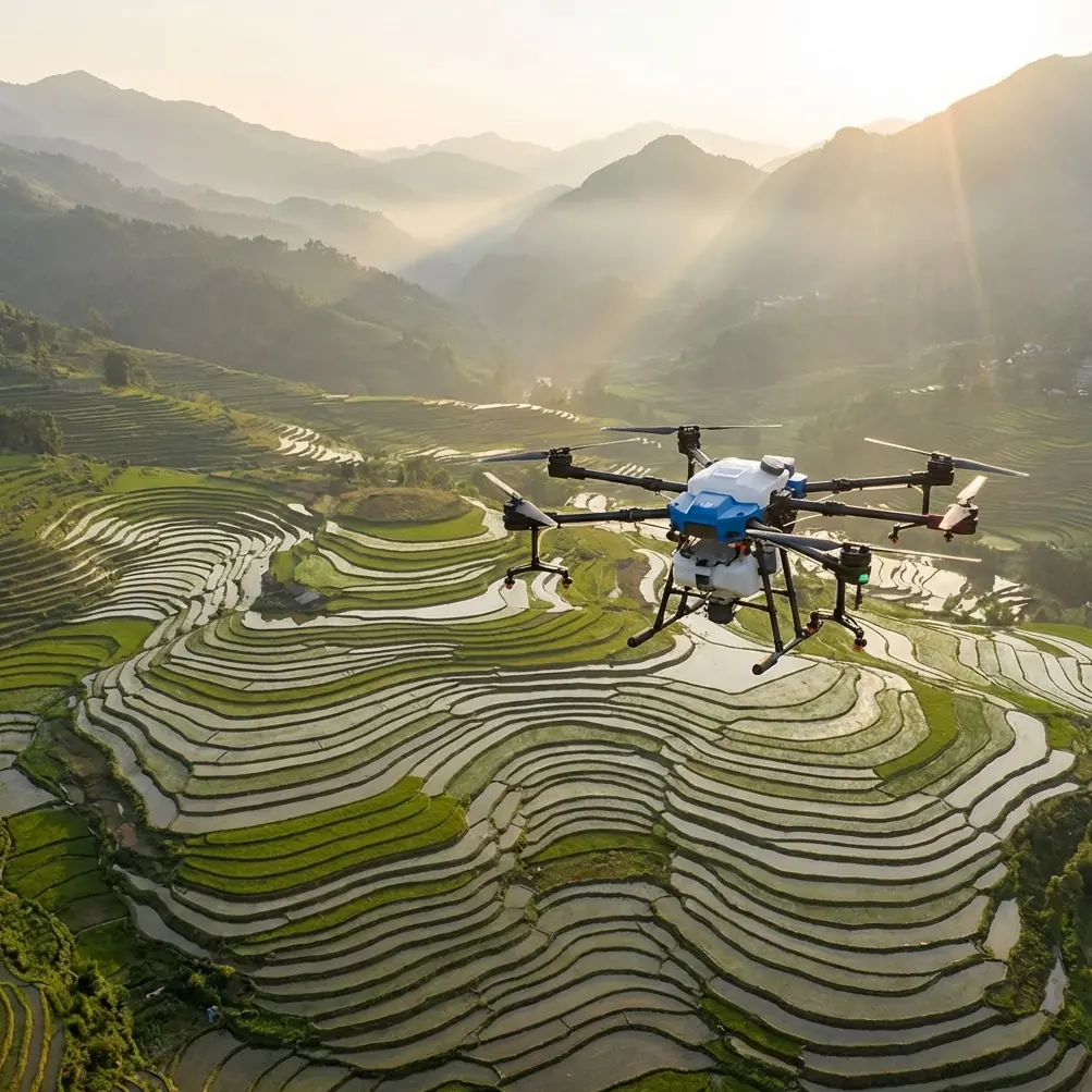
Agras T100 at High Altitude: What Field Capture Really Demands
META: A field-focused look at Agras T100 high-altitude crop capture, low-altitude sample collection, flight safety, RTK precision, and efficient agricultural survey workflows.
People often assume the answer to better agricultural aerial data is simple: fly lower, get sharper images, solve the problem. In real farm operations, that logic breaks down fast.
That is exactly where a discussion about the Agras T100 becomes useful. Not as a generic “smart farming” symbol, but as a working platform in a terrain-sensitive, efficiency-sensitive capture workflow. If your job involves covering fields from higher altitude and still extracting reliable crop intelligence, the real challenge is not image sharpness alone. It is balancing area coverage, flight time, terrain risk, interpretation quality, and the practical reality of what happens when conditions shift halfway through a mission.
Agras T100 operators working in broad agricultural blocks already know the pattern. You need enough altitude to cover ground efficiently. You also need enough detail to classify crops, verify conditions, and support operational decisions without turning every survey into a battery-draining low pass over every parcel. That tension sits at the heart of the reference material, and it matters directly for high-altitude capture planning.
The mistake many teams make: treating all imaging flights the same
The reference workflow makes a sharp distinction between two jobs.
One job is collecting high-definition orthomosaic imagery over a large area. In the cited case, that mission was flown at about 100 meters. The other job is acquiring low-altitude interpretation sample points, done at roughly 15 meters. Those are not interchangeable flight profiles. They serve different purposes, consume resources differently, and carry different risk.
This is a critical operational point for Agras T100 users. High-altitude field capture is not inferior because it sits higher. It is efficient because it covers more area per image and keeps the aircraft moving through the task with fewer photos, less battery draw, and a more manageable processing load. That matters when you are building farm-scale orthomosaics or trying to document large planting zones before spraying, topdressing, or crop response analysis.
Drop to 15 meters and the image becomes much richer. You get closer to leaf-level visual cues. But every photo covers less ground, so the drone must fly slower and capture more frames just to cover the same sample area. The source documents are blunt about the consequence: battery use and flight time can rise by multiples compared with the higher-altitude plan, and office-side orthomosaic generation time also scales up because there are far more images to process.
That is not a small inconvenience. It changes whether a mission is practical.
Why this matters specifically for Agras T100 high-altitude capture
The Agras T100 conversation should not be reduced to whether the aircraft can fly a mission. The more useful question is whether it can support a disciplined workflow where high-altitude coverage is the backbone and low-altitude capture is used surgically.
For a reader focused on capturing fields in high altitude, the key lesson is this: the best workflow is rarely “collect everything at the lowest possible altitude.” It is usually “collect broad orthographic coverage efficiently, then use selective low-altitude passes only where they add interpretive value.”
That is exactly what the ArcGIS agricultural survey logic shows. A sample library built from a smaller number of low-altitude interpretation points can reduce the need to revisit every plot. In the referenced case, interpretation data from plot 69 was sufficient to help determine the crop types in plots 51 and 52. Operationally, that is huge. It means one well-chosen sample can help classify neighboring or comparable fields without repeating the same close-range capture routine across the entire block.
For an Agras T100 operator, this translates into fewer disruptive low-altitude flights, lower cumulative exposure to obstacles, and a faster route from flight to decision.
High altitude is not just about efficiency. It is also about safety.
The reference documents highlight a point many planning teams underestimate: terrain variability can reach tens of meters in agricultural investigation areas. That alone changes the risk profile of automatic low-altitude missions.
At 15 meters, a field may look manageable on a map and still become dangerous in practice. A rise in ground elevation, a tree line taller than expected, or power lines near a boundary can turn an automated route into a collision hazard. The source text explicitly warns about risks like striking hillsides, trees, or wires during low-altitude auto flight.
That insight belongs at the center of any serious Agras T100 article, because agricultural flight planning is never just about what the aircraft can see. It is about what the aircraft may not have enough margin to avoid.
Agras T100 missions flown higher over fields create breathing room. That extra vertical buffer matters when topography changes unexpectedly across a valley edge, terraced section, or wind-exposed slope. It also matters when real-time conditions deteriorate.
And this is where the narrative spark from the brief becomes realistic. Imagine a mission that starts in stable morning light, then halfway through the run the weather shifts. Wind picks up. A bright overcast closes in. A ridge section that was visually clear becomes flatter and harder to read from the ground. In those moments, a high-altitude capture strategy is often more forgiving than an aggressive low-altitude automation plan. You are carrying more spatial margin, you have fewer photos left to collect per hectare, and your route is less vulnerable to the micro-obstacles that become serious when the aircraft is flying close and slow.
In plain terms: when weather changes mid-flight, altitude margin is not wasted space. It is risk control.
The hidden labor behind low-altitude sample capture
Another strong detail from the source material is the human burden of collecting interpretation sample points. These captures are not fully effortless. Operators may need to shoot manually and constantly watch the live video feed to identify nearby hazards such as terrain breaks, elevated vegetation, and electrical lines.
That is operational friction, not just pilot workload.
If you are running Agras T100 missions over large agricultural zones, every extra manual intervention has a cost. It slows the day, complicates consistency between crews, and increases the chance that one team member interprets a hazard differently from another. The reference even notes that, in testing, collecting low-altitude interpretation sample photos for one sample area consumed slightly more battery and time than shooting the orthomosaic for that same area.
That should reset expectations for anyone planning a “more detail everywhere” strategy.
The smarter model is to use Agras T100 high-altitude capture as the scalable layer, then reserve low-altitude work for the places where it actually improves crop interpretation, nozzle planning, or treatment verification.
Where RTK precision and mapping discipline fit in
When people hear “high altitude,” they sometimes worry that positional certainty will suffer. In reality, this is where RTK Fix rate and centimeter precision become central to workflow quality. If your Agras T100 mission is intended to support repeatable agricultural action, clean geospatial alignment matters just as much as visual clarity.
A reliable RTK fix helps ensure that broad-area capture aligns with field boundaries, treatment zones, and repeat missions across the season. That becomes especially valuable when you are comparing orthomosaics with later agronomic tasks or bringing in additional layers like Multispectral data from a separate sensing workflow. High-altitude visible imagery may handle coverage and context. Supplemental datasets can handle stress detection, vigor mapping, or variable-response planning. The aircraft mission does not need to force one altitude to solve every information problem.
This layered approach is usually more robust than trying to extract all answers from ultra-low-altitude visual capture alone.
What weather shifts reveal about workflow quality
Mid-flight weather changes expose weak plans.
If the wind starts to move across open farm blocks, one of the first things that suffers is consistency. Capture overlap can become less predictable. Flight timing stretches. If the same aircraft is also being used later for application tasks, operators begin thinking ahead about Spray drift and whether the current weather trend may compromise subsequent operations. That is not a separate concern. Survey and treatment planning are linked.
A disciplined Agras T100 team reads the capture mission as part of a wider operational chain. High-altitude imaging can tell you whether the field is ready, where variability is concentrated, and whether conditions justify a more targeted intervention. Then the workflow transitions into application readiness, where Nozzle calibration, swath management, and drift awareness become the next critical controls.
This is why high-altitude capture should not be seen as detached from spraying. It is often the decision layer that determines whether the spraying mission is broad, selective, delayed, or adjusted.
A weather change in the middle of imaging is therefore not just an aerial photography issue. It is an early warning for the rest of the farm day.
Why a sample library beats endless re-flying
The source documents make one especially practical argument: once low-altitude interpretation points accumulate across several sample areas, they begin to form a usable sample library. At that stage, office analysts can infer crop types in other areas through correspondence rather than repeated close-range field acquisition.
This has direct value for an Agras T100-based operation.
First, it compresses field time.
Second, it lowers exposure to obstacle-heavy low-altitude routes.
Third, it speeds seasonal scaling because crews are not starting from zero in every block.
Fourth, it improves consistency in crop identification when the same comparative references are used across neighboring fields.
The example of 69 informing 51 and 52 is more than a neat anecdote. It shows the practical leverage of representative sampling. Good field intelligence is not always about collecting more data. Often it is about collecting the right reference data once, then using it intelligently.
If you are building a repeatable survey method around Agras T100, this principle can save entire days over a season.
High-altitude capture does not mean low-detail thinking
There is a misconception that broad-area flights are somehow too abstract to be useful. That usually comes from teams that treat orthomosaics as endpoints instead of decision tools.
In reality, high-altitude field capture can support route planning, crop block verification, drainage pattern review, obstacle awareness, treatment boundary checks, and seasonal comparison. It can also guide where low-altitude verification is worth the risk and effort.
This is especially relevant on large farms where terrain undulates sharply or where infrastructure interrupts clean flight lines. A wide-view pass often reveals the operational truth faster than a hyper-detailed but narrow slice of the field.
And if your operation is working around wet weather, dust, or washdown-heavy routines, durability still matters. An aircraft platform expected to keep moving through agricultural conditions benefits from a design mindset aligned with field realities, including protection standards such as IPX6K. In agriculture, reliability is rarely glamorous. It is just decisive.
A better way to think about Agras T100 in the field
The most useful framing is not “How low can it fly to get detail?” It is “What is the safest and most efficient split between broad capture and selective close inspection?”
That question is what separates a long day from a productive one.
Use the higher-altitude mission to map the whole operating picture. Use low-altitude sample capture only where it materially improves interpretation. Keep RTK discipline high so the data remains usable for repeat workflows. Treat weather changes as workflow signals, not just inconveniences. And never assume that closer automatically means better when terrain, wires, trees, and battery consumption are all part of the same equation.
If you are planning a field-capture workflow around the Agras T100 and want to compare routing logic, sample-point strategy, or RTK setup for mixed terrain, you can message our field team here.
The real win with Agras T100 at high altitude is not simply covering more hectares per flight. It is avoiding the trap of solving every agricultural imaging problem with the same altitude, the same speed, and the same mission logic. The reference material makes that clear. Efficient orthomosaic collection at around 100 meters, selective interpretation capture near 15 meters, and intelligent reuse of sample data across plots is not a compromise. It is a mature operational model.
And in agriculture, maturity beats brute force every time.
Ready for your own Agras T100? Contact our team for expert consultation.