Agras T100 for Mountain Forest Work: A Field Guide to Safer
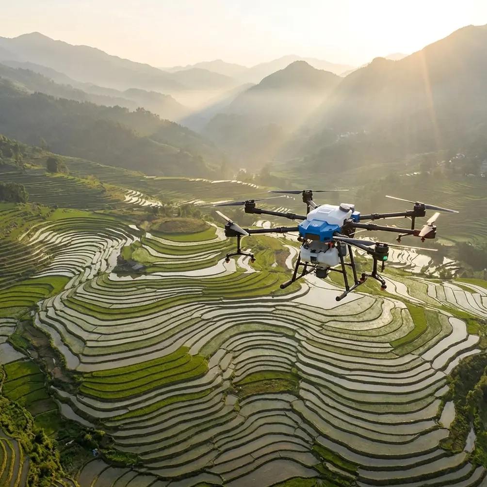
Agras T100 for Mountain Forest Work: A Field Guide to Safer, More Accurate Coverage
META: Expert how-to guide on using the Agras T100 in mountain forests, with practical advice on spray drift, nozzle calibration, RTK fix stability, swath width, multispectral scouting, and rugged wet-weather operations.
Mountain forest work punishes weak assumptions.
I learned that the hard way on a steep reforestation site where the canopy broke into irregular layers, the access road washed out after rain, and every map looked cleaner on a laptop than it did on the slope. The core problem was never just getting a drone into the air. It was getting repeatable coverage when terrain, wind channels, tree height, and signal quality kept changing every few minutes.
That is where the Agras T100 stands out for forestry operators who need usable results instead of tidy specifications. If your job is capturing forests in mountain terrain—whether that means documenting stand conditions, supporting targeted treatment plans, or managing difficult spray missions along steep contours—the T100 is not simply helpful because it is powerful. It is helpful because it reduces the number of small operational failures that usually ruin a mountain job: drift, overlap errors, unstable positioning, poor route confidence, and downtime after wet or dirty field days.
This guide focuses on how to use the Agras T100 intelligently in mountain forests, especially when your priority is accurate, efficient coverage rather than easy flat-field flying.
Start with the problem the mountain creates
Forests on slopes produce three distortions that matter immediately.
First, your apparent distance to the canopy changes constantly. A route that looks uniform in plan view may place the aircraft too high over one section and too low over the next. That affects both image consistency and spray performance.
Second, wind behaves badly. Valleys funnel it, ridgelines accelerate it, and gaps in the tree line create sudden lateral pushes. Spray drift becomes a genuine operational risk rather than a theoretical concern.
Third, positioning confidence is often weaker than operators expect. Tree cover, terrain masking, and moisture-heavy weather can all degrade your RTK Fix rate just when you need centimeter precision to hold a clean line on a narrow treatment corridor.
The T100 matters here because its value shows up in the margins. In mountain forestry, the margins decide whether a mission is merely completed or actually useful.
Step 1: Treat mapping and application as one workflow
A common mistake is separating capture from action. Teams map first, then return later to spray or inspect, often with route assumptions that no longer match the real terrain or canopy pattern.
With the T100, the smarter approach is to build a single forest workflow:
- Scout the stand.
- Identify terrain breaks, dense canopy pockets, exposed edges, and likely drift zones.
- Confirm where RTK lock is dependable and where it degrades.
- Set swath width based on the forest geometry, not on an idealized open-area number.
- Fly application or capture missions with those constraints already built into the plan.
This matters because mountain forests are dynamic environments. A ridge-facing pine block and a sheltered mixed stand may sit only a few hundred meters apart yet require very different flight behavior. The operator who adapts swath width and route spacing to those realities gets more consistent results than the operator who simply imports a default template.
If you are coordinating teams in the field and want to compare mission planning notes before deployment, I often recommend using a quick field message thread like this direct setup channel so route edits and terrain observations stay tied to the active mission.
Step 2: Protect coverage quality by managing spray drift first
In flat agricultural work, drift is serious. In mountain forests, it becomes structural. A slight crosswind at launch can turn into a stronger lateral stream halfway along a slope. Add uneven canopy height and your droplets may miss the intended target zone entirely.
This is why spray drift should be your first operational filter, not a final checklist item.
With the Agras T100, drift control begins with route timing. Early morning often gives the best stability, but in mountain zones that is not always enough. Watch how air moves through gullies and between tree stands. If the slope creates recurring sideways movement, shorten the effective pass length and break one long mission into smaller directional segments. That keeps the aircraft from spending too long exposed to one unstable wind corridor.
Nozzle calibration is equally critical. Forestry teams sometimes talk about throughput first, but nozzle setup is what decides whether your application pattern remains useful at changing heights above vegetation. If your nozzle calibration is off, a technically successful flight can still produce poor deposition. On mountain routes, even a small calibration error becomes magnified because the aircraft is already dealing with variable relative height and irregular target surfaces.
Operationally, that means three practical rules:
- Recheck nozzle calibration whenever you move between stands with clearly different canopy structures.
- Avoid assuming one droplet profile suits both sheltered interior sections and exposed edge lines.
- Reduce confidence in any route where terrain forces abrupt vertical changes over short horizontal distance.
The T100 helps because it is built for serious field duty, but rugged hardware alone does not solve drift. Good operators use the platform’s stability to support discipline, not replace it.
Step 3: Use RTK performance as a mission-go decision, not a background metric
People like the phrase centimeter precision because it sounds definitive. In forest mountains, it is conditional.
Centimeter-level positioning is only meaningful if your RTK Fix rate remains stable across the actual route. That stability can drop near steep terrain walls, under partial canopy influence, or in moist atmospheric conditions common after rain. If your fix is unreliable, your overlap, corridor alignment, and return-pass consistency all suffer.
For the T100, the operational lesson is simple: treat RTK health as a live safety and quality variable.
Before a full mission, run a short route over the most difficult section, not the easiest one near launch. Check whether the fix remains steady where the canopy closes in or the terrain blocks part of the sky view. If it does not, redesign that section. Sometimes the answer is changing the route direction. Sometimes it is shifting the takeoff point to improve geometry. Sometimes it is narrowing the mission scope for that flight window.
This is where the T100 becomes easier to trust than lighter-duty systems often used beyond their comfort zone. In mountain forestry, you are not chasing theoretical accuracy. You are trying to maintain enough positional confidence that every pass still means something when you review the output later.
A high RTK Fix rate is not just a navigation statistic. It is the difference between a treatment corridor that stays within its intended boundary and one that bleeds into adjacent vegetation or misses a critical strip on a steep contour.
Step 4: Set swath width for the forest you have, not the one you wish you had
Swath width is one of the most misunderstood settings in mountain operations.
Operators naturally want wider passes because wider passes promise fewer turns, faster coverage, and better daily productivity. In forests, especially on slopes, that instinct often backfires. A wide theoretical swath may collapse in practice once terrain angle, canopy gaps, and wind variation are introduced.
The better method is to establish a conservative swath width first, then expand only after reviewing real coverage consistency. In dense or uneven stands, a narrower swath frequently produces better total efficiency because it reduces rework. Rework is expensive in mountain terrain even when no money is mentioned: it costs battery cycles, daylight, operator concentration, and access time.
The T100 is well suited to this because it gives operators enough platform confidence to make precision-oriented decisions rather than chasing headline coverage. In other words, the machine is capable enough that you can afford to fly smarter.
As a rule, decrease swath width when:
- The slope changes sharply within a single pass.
- Tree height varies enough to distort your target distance.
- Wind direction shifts across the route.
- RTK confidence weakens in only part of the stand.
Increase only when those variables are proven manageable, not merely assumed to be manageable.
Step 5: Use multispectral intelligence selectively, not decoratively
Forestry teams sometimes over-collect data. They fly because they can, not because the next decision needs that data.
In mountain forest work, multispectral information is most useful when it changes what you do on the next mission. For example, if multispectral review shows stress patterns along a drainage edge or on a sun-exposed ridge shoulder, that can justify route adjustments, narrower treatment zones, or revised pass priority. That is practical intelligence.
The Agras T100 becomes more valuable when integrated into that decision chain. Instead of treating capture and action as separate departments, use multispectral observations to refine mission geometry. A stressed patch on a slope may require slower, more conservative coverage because canopy structure is thinner and drift exposure is higher. A healthier, denser section may need a different spacing logic altogether.
The point is not to gather beautiful layers. The point is to reduce uncertainty before the aircraft enters a difficult corridor.
Step 6: Take weatherproofing seriously because mountain work is rarely clean
One of the most useful details for this kind of environment is IPX6K protection. In mountain forests, that rating is not a brochure flourish. It has direct field significance.
You are dealing with mist, splashback, muddy staging areas, wet foliage, and residue accumulation after repeated operations. A platform with IPX6K-level protection is simply more realistic for crews that work in bad access conditions and do not have the luxury of a spotless flat launch zone every day.
That does not mean careless maintenance is acceptable. It means the aircraft is better aligned with actual forestry use. You can clean and turn around the system with more confidence after exposure to water and debris, which matters when weather windows are short. In mountains, losing half a day to avoidable contamination or post-flight cleaning complications can mean losing the only calm operating period you had.
This is one of those specifications whose importance grows when the terrain gets worse. For forest work, it is operational resilience, not just durability.
Step 7: Build routes around escape options
The best T100 operators in mountain forests think one pass ahead and one exit ahead.
Do not plan only for ideal route completion. Plan for interruption. A sudden downdraft near a ridge edge, a drop in positioning confidence, or an unexpected obstacle profile can force a mission change quickly. When that happens, the route should already include safe break points and clean return paths.
This is especially important where forest roads are limited and visual perspective is distorted by slope angle. Shorter segmented missions are often superior to one elegant large block. They improve judgment, reduce cumulative error, and make post-mission analysis more honest.
The T100 makes this easier because it is designed for serious work, but the key improvement still comes from route architecture. A strong aircraft does not rescue a weak plan.
The real advantage of the T100 in mountain forests
The Agras T100 is not easier because mountain forestry becomes simple. It is easier because the aircraft helps remove friction from a job that is naturally difficult.
It supports disciplined nozzle calibration when target geometry changes. It rewards conservative swath width decisions instead of punishing them. It makes centimeter precision genuinely useful when your RTK Fix rate is healthy. Its IPX6K protection fits wet, dirty forest staging conditions that less field-ready systems struggle with. And when paired with focused multispectral scouting, it helps teams stop guessing where the terrain is likely to compromise coverage.
That combination matters most to operators who have already experienced the old pattern: launch, improvise, compensate, repeat. The T100 does not eliminate judgment. It makes good judgment easier to execute.
If your work involves capturing or treating forests in the mountains, that is the distinction worth caring about. Not whether the drone sounds advanced, but whether it helps you produce repeatable results on the kind of terrain that usually exposes every weakness in your process.
Ready for your own Agras T100? Contact our team for expert consultation.