Agras T100 in Urban Vineyards: What a Crop
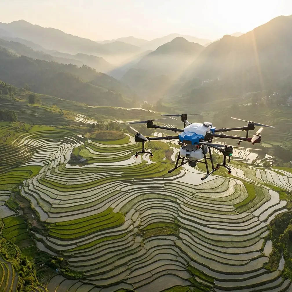
Agras T100 in Urban Vineyards: What a Crop-Survey Workflow Really Demands
META: A field-based Agras T100 case study for urban vineyard work, covering imaging workflow, orthomosaic processing, ArcGIS crop interpretation, RTK discipline, and practical camera setup under difficult light.
Urban vineyards expose every weak point in a drone workflow.
Space is tighter. Reflections from glass, roofs, cars, and irrigation hardware can unsettle positioning. Light changes faster than many pilots expect because rows move in and out of shadow from buildings, trees, and slope breaks. And when the mission is not just spraying a block, but documenting vine condition, boundary consistency, and adjacent parcel context, the job shifts from simple flight execution to evidence-grade data capture.
That is where the Agras T100 conversation gets more interesting.
Most coverage of agricultural drones stays trapped in a narrow frame: tank size, throughput, and broad-acre efficiency. That misses what matters for vineyards on the edge of urban environments. In these sites, the drone is part aircraft, part sensor platform, part GIS input device. If the imagery is weak, the analysis is weak. If the positioning is sloppy, the treatment map and field interpretation drift apart. If the operator is buried in manual camera adjustments, valuable attention leaves the row geometry, wind behavior, and obstacles that actually determine mission quality.
A better way to think about the T100 is as the front end of a disciplined agronomic data chain.
The real field problem: seeing enough, not seeing everything
One of the most useful insights in the reference material comes from an ArcGIS-based crop survey workflow. In that example, analysts were able to determine that plots 51, 52, and 69 contained the same crop by comparing high-resolution orthomosaic imagery. Plot 69 had a known interpretation point, and from the image pattern they could infer that 51 and 52 were also corn, even without separate sample points. That matters because agricultural drone work is rarely about identifying every plant individually. It is about identifying repeatable spatial patterns that are strong enough to support decisions.
That same logic applies in vineyards.
A T100 mission over an urban vineyard does not need to resolve every leaf edge to be useful. It needs to produce stable, georeferenced imagery where row texture, canopy continuity, missing-vine gaps, edge encroachment, water stress clues, and block-to-block differences remain readable and comparable. In practice, decision-grade imagery is about consistency first. Detail comes second.
Another reference makes this point even sharper. In the ArcGIS integrated collection workflow, the orthomosaic was processed successfully, but the authors explicitly noted that even after zooming in, they still could not identify crop type simply by “seeing leaves clearly.” Operationally, this is a crucial warning for T100 users: do not confuse high resolution with automatic interpretability. A sharp image is not the same as a useful agronomic image.
For vineyard operators, that means flight planning, camera discipline, and GIS context have to work together.
Why camera automation matters more than many pilots admit
The photography reference in the source set looks unrelated at first glance. It discusses two camera combinations: aperture priority with Auto ISO, and manual exposure with Auto ISO. But for vineyard capture in mixed urban light, this is one of the most practical operational details in the entire brief.
The reason is simple. During low-altitude runs along vineyard rows near urban structures, luminance can change abruptly. A block edge may face open sky on one side and a reflective wall on the other. If the pilot or sensor operator is stopping repeatedly to chase ISO manually, the mission rhythm falls apart. Worse, attention shifts away from safety, overlap discipline, and route fidelity.
The source argues that A mode plus Auto ISO, and M mode plus Auto ISO, can cover most shooting conditions as long as the operator sets an ISO ceiling and a minimum safe shutter speed in advance. That pre-configuration is not a casual detail. It is the safeguard that keeps noise and motion blur inside known limits while still allowing the camera to respond to changing light.
On an Agras T100 vineyard mission, this has direct significance:
- A defined ISO upper limit helps preserve texture in canopy imagery so later orthomosaic stitching and visual interpretation are not undermined by excessive noise.
- A minimum safe shutter protects against blur from aircraft motion and row-pass vibration, especially when flying in constrained urban air where smooth, long unbroken tracks are not always possible.
- Auto ISO reduces cockpit workload, freeing the operator to watch spacing, swath alignment, and interference-prone areas rather than fiddling with exposure every few minutes.
This is exactly the kind of field discipline that separates pretty footage from usable farm data.
Electromagnetic interference is not a theory in urban vineyards
The urban vineyard scenario introduces another factor that broad-acre operators can sometimes ignore: electromagnetic interference. Power lines, rooftop communications equipment, perimeter security systems, nearby buildings, and metal infrastructure can all complicate GNSS behavior and degrade the RTK Fix rate if the setup is careless.
That is why antenna adjustment deserves more attention than it usually gets.
When working with a platform like the Agras T100 in vineyard corridors near urban edges, the antenna orientation and the physical setup of the controller or base system can influence how cleanly the aircraft maintains centimeter precision. This is not just a mapping issue. It affects path repeatability, swath accuracy, and confidence around treatment boundaries where spray drift risk is already sensitive because vines often sit close to roads, residences, or neighboring specialty crops.
In practical terms, handling interference starts before takeoff:
- Position the ground equipment away from obvious reflective or radiating sources when possible.
- Adjust antenna angle deliberately rather than leaving it in a habitual position from open-field operations.
- Watch the RTK Fix rate before committing to a full mission, especially near structures and utility corridors.
- If fix stability degrades on one side of the block, do not assume it is a random fluctuation. Recheck orientation, local obstruction, and interference sources.
For urban vineyard operations, centimeter precision is not a luxury metric. It is what keeps row-based work orderly when the margin for error is narrow.
Processing choices shape what the vineyard team can actually use
The ArcGIS processing document includes a deceptively valuable detail: in the Processing Options workflow, the operator enables Initial Processing with default settings, then selects Orthomosaic output while leaving Digital Surface Model creation unchecked. In that case, the goal is to produce the orthophoto only, not a DSM.
This matters because too many drone teams overproduce data and underdeliver decisions.
For many urban vineyard use cases, the orthomosaic is the primary deliverable that drives action. It is what managers use to inspect row consistency, compare canopy density patterns, flag missing sections, and align field observations with parcel boundaries. If the operational question is visual crop interpretation and block-level review rather than terrain modeling, generating only the orthomosaic can simplify the workflow and reduce processing burden.
That burden is not trivial. The same document reports a measured processing time of roughly 1 to 6 hours per plot, depending on photo resolution, image count, and hardware performance, especially CPU core count and memory. For a consultant or grower using the Agras T100 as part of a vineyard documentation program, that number is operationally significant.
It affects:
- how many blocks can be turned around in a day,
- whether same-day decision support is realistic,
- what workstation specifications are justified,
- and how aggressively image volume should be managed in the field.
In other words, every extra image you capture has a downstream cost. Efficient overlap and disciplined route design matter just as much after landing as they do in the air.
The productivity lesson the T100 crowd should not ignore
The strongest proof point in the agricultural survey reference is not a camera setting or a software screen. It is the team productivity comparison.
Using a traditional tablet-based field collection process, a 7-person team could collect and enter one sample area in a day. Using a drone plus ArcGIS workflow, a 2-person field-and-office team could complete 3 sample areas in one working day. The stated efficiency improvement was about 10.5 times.
That is a profound shift.
Now translate that into the urban vineyard context. A T100-supported operation can compress what used to require multiple ground staff into a smaller team that captures the site once, processes it systematically, and shares the results across stakeholders. Vineyard managers, agronomists, consultants, and owners do not all need to be present in the rows at the same time to understand the same block. The imagery becomes the common reference.
This is particularly useful when the vineyard is fragmented across multiple urban-adjacent parcels. Instead of relying on handwritten notes and uneven field observations, the operation can standardize what was seen, where it was seen, and how it relates to prior captures.
ArcGIS is where isolated flights become a management system
Agras T100 missions create value fastest when the output is not trapped on a hard drive.
The ArcGIS reference highlights Portal for ArcGIS as a sharing environment for geospatial information across organizations, devices, and users. It specifically notes that orthomosaic imagery, sample points, and oblique model outputs can be shared there. For vineyard operators, this is the bridge between flight activity and management action.
A single flight has limited value if only the pilot can interpret it. A shared geospatial portal changes that.
Imagine a consultant documenting an urban vineyard affected by edge stress near roads and buildings. The orthomosaic is uploaded, row notes are attached, and problem areas are tagged. The vineyard manager reviews from the office, the field team verifies on the next pass, and the agronomist compares the pattern against prior captures. That is a far more durable workflow than sending screenshots in a messaging thread.
The same source also points to a growing archive problem: once drone outputs accumulate across dates, areas, and resolutions, it becomes difficult to retrieve the right image quickly unless metadata is managed properly. For vineyards monitored through the season, that warning is highly relevant. A T100 program without image management discipline becomes a storage problem masquerading as a precision-ag project.
If you are building this kind of workflow and want to compare setup notes for vineyard blocks with difficult signal conditions, you can message our UAV team directly on WhatsApp.
What this means specifically for an Agras T100 vineyard operator
The most credible way to use an Agras T100 in urban vineyards is not to chase a fantasy of perfect automation. It is to build a resilient workflow around known constraints.
That workflow looks like this:
First, fly for interpretable output, not vanity detail. The reference material makes clear that even very sharp orthomosaics do not guarantee leaf-level crop identification. In vineyards, your goal is readable row patterns and consistent canopy signals.
Second, simplify exposure management. The A mode plus Auto ISO or M mode plus Auto ISO approach is effective because it cuts down manual intervention. But it only works properly if ISO limits and minimum shutter thresholds are defined before flight.
Third, treat RTK behavior as a live quality variable in urban settings. Antenna adjustment and interference awareness directly affect row accuracy, boundary confidence, and treatment precision.
Fourth, process selectively. If the operational need is an orthomosaic for visual analysis and GIS integration, do not generate unnecessary outputs that consume time and hardware resources. The documented 1 to 6 hour processing window per plot is enough reason to be selective.
Fifth, think beyond the sortie. The real efficiency gains appear when a small team can gather, process, classify, share, and statistically analyze multiple sample areas in one day. The cited comparison showing a roughly 10.5x efficiency increase is not just a bragging point. It is evidence that drone-based agricultural workflows alter staffing models and reporting speed.
The bottom line
For urban vineyards, the Agras T100 should be judged less by raw aircraft specification and more by how well it supports a complete operational chain: stable capture in difficult light, disciplined positioning under interference pressure, efficient orthomosaic generation, and GIS-based interpretation that scales beyond one flight.
The reference set points to a mature truth that many buyers miss. Useful agricultural drone work is rarely won by one feature. It is won by the quality of decisions before takeoff and after landing.
Set Auto ISO boundaries so the camera helps instead of distracts. Monitor RTK fix stability where urban infrastructure pushes back. Build orthomosaics for interpretation, not for bragging rights. And store results where teams can actually use them.
That is how an Agras T100 becomes more than a machine over vines. It becomes part of a repeatable survey and management system.
Ready for your own Agras T100? Contact our team for expert consultation.