Agras T100 for High-Altitude Construction Site Delivery
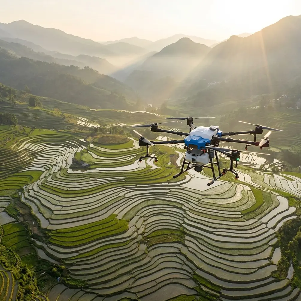
Agras T100 for High-Altitude Construction Site Delivery: What Actually Matters in the Field
META: A practical expert guide to using Agras T100 around high-altitude construction delivery workflows, with a focus on flight planning, restricted-area compliance, human oversight, and operational reliability.
High-altitude construction sites expose every weakness in a drone operation. Airspace gets complicated. Weather shifts fast. Ground access is often poor. And when a site is remote, the drone is not just a convenience tool; it becomes part of the logistics chain.
That is where interest in the Agras T100 starts to make sense.
But the real question is not whether the platform looks capable on paper. The question is whether it can be integrated into a disciplined delivery workflow that survives altitude, regulation, and site complexity. For that, the most useful lens is not marketing. It is operations.
As a consultant, I would frame the T100 less as a “flying machine” and more as a managed field system. That distinction matters, especially for readers thinking about delivering supplies or technical materials to mountain projects, elevated rail works, transmission corridors, or remote infrastructure construction zones.
The first mistake: treating autonomy as a substitute for planning
One of the most grounded points in the reference material has nothing to do with payload specs. It says that even as drones become more intelligent, technicians still need to create flight plans, and personnel still need to control the real-time ground monitoring system. That is a blunt reminder: smarter aircraft do not remove the need for competent people.
For an Agras T100 deployment at a high-altitude construction site, this translates into a simple rule. Mission success depends on planning before takeoff, not just stability after takeoff.
At elevation, route design becomes tighter because terrain compresses safe margins. A path that looks clean on a map can become a hazard when ridge lift, crosswinds, or abrupt elevation changes affect the aircraft. If your workflow includes repeated trips between a staging area and an active construction face, the T100 has to be flown inside a planned corridor with clear abort options.
That is where strong positioning performance matters. In practical terms, operators often look at RTK fix rate and centimeter precision not as abstract technology badges, but as confidence tools. A stable fix helps keep launch, approach, and drop or handoff points repeatable. On uneven mountain construction sites, repeatability is not cosmetic. It reduces wasted movement on the ground and lowers the chance of drifting into unsafe approach paths.
Compared with less disciplined platforms that rely heavily on broad GPS guidance and operator correction, a more robust workflow around the T100 can produce cleaner route consistency. That becomes especially valuable when the job is not a one-off demo flight, but multiple daily runs supporting an active build.
Restricted areas are not a footnote. They are central to the mission.
The reference regulations are very clear on one point: the pilot in command must ensure the drone complies with requirements related to restricted areas and avoid entering them. For users connected to a drone cloud system, the system’s restrictions must be followed. For users outside that ecosystem, the operator has to independently understand how restricted zones are defined and must not breach prohibited airspace, unapproved restricted zones, danger areas, or airport obstacle limitation surfaces.
This matters more for high-altitude construction delivery than many teams realize.
Mountain and elevated construction work often happens near infrastructure corridors. Those corridors can overlap with sensitive airspace logic even when the site feels isolated. A team that assumes “remote” means “free airspace” is setting itself up for operational failure.
If you are building a T100 delivery program, geospatial validation needs to happen before every mission block, not just once at project kickoff. Access roads change. crane positions change. temporary site boundaries change. Nearby emergency activity can also affect local airspace risk. A cloud-connected workflow helps, but it does not remove pilot responsibility.
This is one area where the better operators separate themselves from the careless ones. Competitors may talk about speed or ease of use, but on a real construction delivery mission, airspace discipline is what keeps the operation scalable. If a platform is being used in a professional environment, it must fit into a restricted-area management process, not operate outside one.
VLOS, BVLOS, and why the distinction affects site logistics
The reference text also distinguishes between visual line of sight and beyond visual line of sight operations. Under VLOS, the aircraft must remain within the visual range of the pilot or observer, operate during daytime, and yield route priority to other aircraft. Under BVLOS, the aircraft must still yield to manned aircraft, and the flight must stop immediately if safety to airspace users or people and property on the ground is threatened. The pilot must be able to control the drone at any time, and even in autonomous mode must be able to override it.
For the T100 user delivering to high-altitude construction zones, this is not just legal housekeeping. It changes how you design the job.
A short hop from a lower staging pad to a visible upper platform may be workable under VLOS with an observer network. A longer ridge-crossing route to a hidden site pocket is a different operational category. If the team does not understand that distinction, they can end up planning a workflow that is efficient on a whiteboard and non-compliant in reality.
The override requirement is especially significant. A delivery drone at altitude cannot be treated like a fully self-governing robot. If gusting conditions, signal anomalies, or unexpected traffic appear, the pilot must be able to intervene instantly. This is where C2 link integrity becomes operationally decisive. The regulation requires an effective air-to-ground command and control link, and that is exactly what construction delivery depends on. Without reliable C2, the rest of the mission stack is academic.
In plain language: if the T100 is chosen for mountain delivery support, its value is not merely in lifting material. Its value is in remaining controllable when the environment starts behaving badly.
Flight data retention is more useful than most crews think
One of the most practical regulatory details in the source is the requirement for a flight data recording system used to record, replay, and analyze the flight process, with data retained for at least three months for certain categories.
That sounds bureaucratic until something goes wrong.
On a high-altitude construction project, keeping at least three months of flight data can reveal patterns that the crew would otherwise miss. Maybe wind shear is repeatedly affecting one approach leg at a particular hour. Maybe one launch point is causing inconsistent heading stabilization. Maybe a route segment near a metallic structure is degrading signal quality. Without recorded data, these issues become anecdotal. With data, they become fixable.
This is also where the T100 can outperform weaker operational setups around competing aircraft. A lot of teams compare drones by lift, battery swaps, or route automation. Those are visible features. The harder, more valuable advantage is post-flight traceability. If your system supports structured replay and analysis, you can refine delivery corridors, tighten safety buffers, and improve site coordination over time.
Professional drone logistics is an iterative discipline. The aircraft that helps you learn faster usually ends up being the better tool.
If the drone is not on a cloud system, identification becomes non-negotiable
Another detail from the reference regulations deserves attention: if a user is not connected to a drone cloud system, the aircraft body must carry clear identification showing the model, number, owner, and contact information, so the operator can be quickly identified if the aircraft crashes.
That requirement has obvious compliance value, but there is also a practical construction-site angle.
High-altitude projects often involve multiple subcontractors, temporary storage zones, shared staging pads, and variable shift crews. Equipment accountability gets messy. A clearly marked aircraft is not just easier to identify after an incident; it is easier to manage during routine operations. On a complex site, clean identification reduces confusion between crews and helps supervisors document which aircraft was assigned to which mission block.
If you are formalizing T100 use across several project zones, add physical labeling and digital mission logging as a standard pair. One protects you in the field. The other protects you in the review.
Human-and-drone coordination is the right model for construction delivery
The second source, focused on aerial survey in contact network engineering, makes a point that applies well beyond surveying: drone operations should not be treated as a total replacement for human work. In demanding conditions, a hybrid model is more efficient. Humans handle part of the measurement or inspection burden, while the drone is used where urgency, access difficulty, or poor conditions make it especially valuable.
That same logic is ideal for high-altitude delivery.
The Agras T100 should not be the answer to every movement problem on site. It should be the answer to the movements where terrain, urgency, or safety justify aerial transport. For example:
- moving lightweight technical items to an upper work face when ground access is slow
- delivering samples, instruments, or urgent maintenance consumables between separated elevations
- supporting inspections after weather disruption when road access is delayed
- maintaining continuity on sites where manual carry routes expose workers to excessive fatigue or hazard
This hybrid model is more realistic than the fantasy of full drone replacement. It also tends to produce better cost discipline, because the aircraft is reserved for the segments where its advantages are clearest.
What makes the T100 especially relevant here
The context around the T100 often includes terms like swath width, nozzle calibration, spray drift, multispectral capability, RTK fix rate, and IPX6K protection. Not all of those belong directly to a construction delivery mission, but they do reveal something useful about the aircraft class and deployment mindset.
An airframe designed for harsh field operations typically has an advantage when moved into rugged logistics support. IPX6K-level protection, for instance, points to a machine built with exposure resistance in mind. On construction sites where dust, moisture, mud, and abrupt weather changes are part of the day, that kind of durability matters. It means less babying between missions and more confidence when the aircraft is operating from imperfect staging conditions.
RTK-based centimeter precision has even clearer relevance. At altitude, your “delivery zone” may be a compact platform, a narrow graded terrace, or a temporary material transfer point. Precision positioning reduces the chaos around approach and handoff.
Even the agricultural language around calibration has a lesson. In spray work, nozzle calibration and spray drift management are about control, consistency, and environmental response. In construction delivery, the same operational mindset applies to route calibration, approach consistency, and wind-aware planning. Different mission, same discipline.
That is why the T100 stands out against more casual competitors. Some platforms are easy to fly in calm, open conditions. Fewer are truly suited to repeatable industrial work where weather, terrain, and procedural compliance all push back at once.
A field-ready tutorial mindset for T100 construction delivery
If I were advising a site team rolling out the Agras T100 for high-altitude delivery, I would use this sequence:
1. Validate the airspace before anything else
Confirm restricted-area status for every route. If operating through a cloud-connected system, follow its limits. If not, independently verify local restrictions and obstacle limitations.
2. Decide whether the mission is truly VLOS or not
Do not blur categories. Build the route and crew plan around the actual operational mode, with observers where needed.
3. Establish a reliable C2 and override procedure
Autonomy is helpful. Immediate manual authority is mandatory. The pilot must be able to intervene without delay.
4. Build a lost-control response plan
The source regulations explicitly point to emergency recovery procedures and reporting processes. Write them down before flight day, not after an incident.
5. Keep complete records
Retain replayable flight data for at least three months where applicable. Use that archive to refine routes, identify recurring site-specific risk, and train crews.
6. Mark the aircraft clearly
If the aircraft is outside a cloud system, label the body with model, serial or number, owner, and contact details.
7. Use the drone where it has the strongest advantage
Do not force every site movement into an aerial workflow. Pair the T100 with human crews intelligently.
This is the part many teams skip. They want the drone to prove itself through dramatic flights. In reality, the best proof is repeatable, uneventful utility.
Final thought: the best T100 operations are boring for everyone except the planner
That may sound strange, but it is true. On a mature high-altitude construction delivery program, the most successful T100 flights are not exciting. They are clean. Controlled. Documented. Repeatable.
The references behind this discussion point in the same direction. Drone work still depends on technicians creating flight plans and supervising ground systems. Human-and-drone coordination often beats pure replacement. Restricted-area compliance is mandatory. Effective C2, data retention for at least three months, and clear aircraft identification are not administrative extras. They are the structure that turns a capable airframe into a professional operation.
If you are evaluating the Agras T100 for mountain or elevated construction logistics, judge it by that standard. Not by noise. By workflow quality.
And if you want to compare route-planning setups or high-altitude site deployment logic with someone who works on these operations directly, you can message Marcus here.
Ready for your own Agras T100? Contact our team for expert consultation.