Agras T100 in Remote Vineyards: Camera Data, Mapping Speed
Agras T100 in Remote Vineyards: Camera Data, Mapping Speed, and the Antenna Detail That Saves a Day
META: A field-based Agras T100 case study for remote vineyard operations, covering RAW imaging workflow, emergency-style mapping logic, antenna positioning, RTK precision, spray drift control, and practical data decisions.
Remote vineyards expose every weakness in an agricultural drone workflow.
Distance stretches your radio link. Terrain breaks line of sight. Light changes fast between rows and slopes. If the operation includes scouting, spot treatment, and documentation for agronomy records, the weak point is often not the aircraft itself. It is the decision chain around it: what data you capture, how fast you can act on it, and whether your link and positioning stay reliable when the site is hard to reach.
That is the right lens for thinking about the Agras T100.
Rather than treating the T100 as just a spraying platform, I prefer to frame it as a field-response system for vineyards where access is inconvenient and timing matters. That framing is supported by two ideas from the reference material. First, one source explains why RAW imagery matters: it preserves near-unprocessed sensor data instead of giving you a heavily compressed, already-interpreted JPEG. Second, an emergency mapping document highlights why drones are so effective when the area is difficult to access: they can reach affected zones quickly, deliver high-resolution information in real time, and support immediate operational decisions. Put those together, and the T100 becomes more than a machine flying rows. It becomes part of a precision response loop.
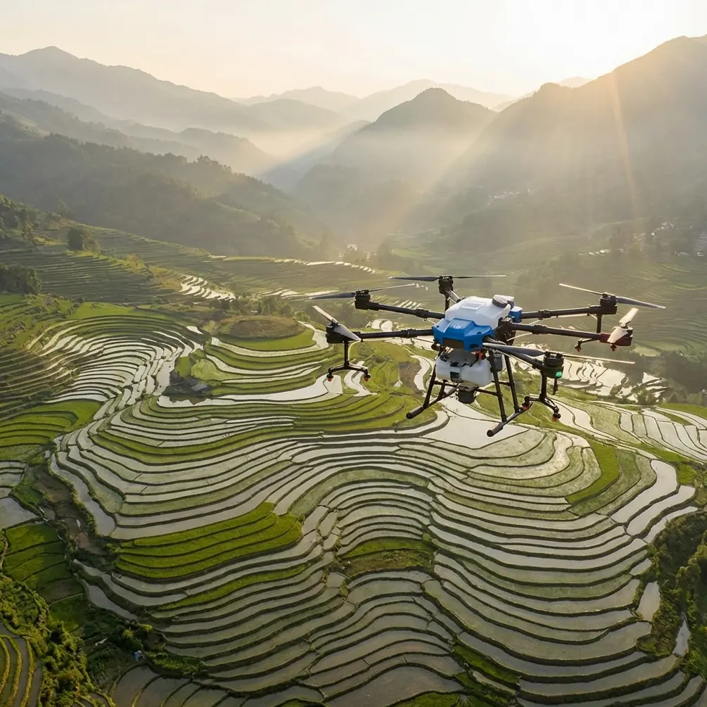
A vineyard case that explains the whole system
Consider a hillside vineyard with patchy connectivity, uneven road access, and a mix of mature vines and younger blocks. The team’s problem is not simply applying product. They need to identify stress in difficult light, confirm whether a disease signature is real or just shadowing, maintain consistent swath width over irregular terrain, and avoid drift near adjacent blocks.
On paper, this sounds like a standard precision-ag task. In reality, remote vineyards behave more like miniature incident zones. The same characteristics that make drones valuable in emergency mapping also make them valuable here: speed, mobility, and the ability to gather high-resolution information without relying on perfect road access or a traditional airfield. The emergency mapping reference states that UAV aerial survey work stands out for timeliness, resolution, and environmental adaptability. That operational logic translates extremely well to steep or isolated vineyards.
When an access road is muddy, a row is blocked, or a slope prevents easy ground inspection, the T100’s value is not theoretical. It is measured in how quickly your team can see the block clearly enough to make a treatment decision.
Why camera format choices matter more than most spray teams admit
A surprising number of agricultural operators still document field conditions in JPEG only, then wonder why post-flight review feels vague. The reference article on camera settings gets to the heart of this: RAW files store the sensor’s near-original data, with far less compression and fewer in-camera edits than JPEG. That matters in vineyards because row shadows, reflective leaves, and bright soil can fool quick-look images.
If you are using the T100 workflow alongside scouting or supplementary imaging, RAW+JPEG is often the most practical setting. The JPEG gives you immediate visibility in the field. RAW gives you room to recover detail later when you need to verify whether a suspected issue was genuine canopy stress, glare, or exposure bias. That is not a photography luxury. It is an agronomic advantage.
The same source also points out the practical differences between 12-bit and 14-bit options, compressed RAW, and storage compatibility. In vineyard operations, those are not abstract camera-menu trivia. They directly affect whether a consultant can pull usable tonal separation from a bright midday scene where disease symptoms are subtle. If your post-processing target includes multispectral correlation or a visual check against plant vigor zones, having deeper image data can prevent expensive misreads.
There is also an operational tradeoff. RAW files are larger. They create more load in storage, transfer, and compatibility. In a remote vineyard, that means your field laptop, tablet workflow, and backup routine need to be set before the day starts. Too many crews discover this only after collecting data in a format their downstream software handles poorly.
My rule for T100 support teams is simple:
- Use JPEG when the mission is immediate visual confirmation only.
- Use RAW+JPEG when the site is complex, the light is uneven, or the images may influence treatment decisions later.
- Be cautious with aggressive compression if you expect to inspect fine vine-level differences after the flight.
The reference article also mentions smartphone RAW use cases. That may sound peripheral, but it is useful in vineyards. Ground-truth images taken from a phone in RAW mode can help confirm what the aerial pass suggested. On mixed terrain, that comparison can keep you from chasing phantom stress patterns.
The emergency-mapping mindset is exactly what remote vineyards need
One of the strongest details in the mapping reference is the emphasis on rapid arrival, high-resolution disaster data, and continuous monitoring when conditions are hard to access. Replace “disaster area” with “remote vineyard block after weather pressure,” and the logic still holds.
Vineyards often require immediate follow-up after heavy rain, erosion, localized flooding, or disease-conducive humidity spikes. A drone that can move quickly into the block and generate current visual intelligence is valuable before a single liter is sprayed. The source specifically notes that UAVs can monitor water-covered areas, help define boundaries, and provide geographic information for dispatch and command. In vineyard terms, the equivalent is identifying where water pooled, where access is compromised, and where intervention should start first.
That is why I advise T100 operators to think in two phases:
- Information phase: establish what actually happened in the block.
- Action phase: apply the correct treatment with calibrated output and controlled drift.
Too many operations jump to phase two.
RTK fix rate, centimeter precision, and why they matter on vine rows
For remote vineyards, RTK performance is not just a specification line. A stable RTK fix rate underpins repeatable pathing, cleaner row alignment, and better treatment consistency on narrow or irregular parcels. If the aircraft cannot maintain centimeter precision where row spacing, terrace edges, or exclusion boundaries matter, you invite overlap, skips, or drift-prone corrections.
This is where antenna behavior becomes more important than most crews realize.
Antenna positioning advice for maximum range
Here is the field habit I push hardest: do not treat the controller antennas as decorative hinges. Their orientation should match the geometry of the site.
For hillside vineyards, keep the antennas oriented to maximize broadside exposure toward the aircraft rather than pointing the tips directly at it. In plain terms, you want the strongest face of the antenna pattern aimed through the flight area. Then position yourself where terraces, tree lines, metal sheds, or slope breaks are least likely to interrupt line of sight during the far end of the route.
A small move by the pilot can matter more than people expect. Walk a few meters uphill. Shift away from a parked vehicle. Avoid standing behind stone walls or dense foliage. If your vineyard has segmented elevation, set up where the aircraft spends most of its mission volume in clean radio view, not where takeoff merely feels convenient.
That advice becomes critical in remote delivery-style terrain as well. One of the logistics references notes how even advanced drone programs ran into practical limits around route structure, regulation, and stable operation. Amazon’s target model, for example, was built around trips within 16 kilometers, with up to 2 kilograms delivered in 30 minutes. Those numbers come from a logistics context, but they illustrate a wider truth: distance is never just about battery and motor efficiency. The communication environment and route geometry decide whether a nominal range is usable.
For an Agras T100 in a remote vineyard, “maximum range” should never mean “farthest possible point on a brochure.” It means the farthest point where you still have healthy command confidence, a dependable RTK solution, and enough margin to handle terrain and weather changes calmly.
Spray drift control starts before the tank opens
The LSI topics around spray drift and nozzle calibration are not accessories here. They are central.
Remote vineyards often sit in exposed microclimates. Wind channels between rows, then shifts again near a ridgeline. If your nozzle calibration is not matched to the product, canopy density, and target deposition, drift becomes much harder to control. The T100 workflow should therefore begin with a calibration discipline that respects three things:
- droplet profile,
- flight speed,
- and actual canopy target height.
This is also where good geospatial intelligence improves spray performance. When the aircraft knows the block accurately and holds track with centimeter precision, you reduce erratic corrections. Fewer abrupt corrections usually means more stable application behavior. Precision in navigation and precision in droplet placement are linked more closely than many teams admit.
Swath width deserves the same scrutiny. A wide swath that looks efficient on flat, uniform ground may become deceptive on vineyard slopes or variable row spacing. In those situations, practical swath width is what maintains consistent coverage without pushing drift risk at the edges. The best operators are not the ones who choose the biggest number. They are the ones who choose the repeatable one.
Data compatibility is a real field issue, not office trivia
The reference material on RAW also mentions file size and compatibility problems. That is highly relevant to drone agriculture because many vineyard teams now move data between aircraft controllers, mobile devices, cloud folders, agronomy software, and external consultants.
A remote site magnifies every weakness in that chain.
If your scout imagery is in a format your analysis software struggles with, or if upload bandwidth is poor, turnaround slows. That delay can matter if disease pressure is building or the weather window is closing. The best T100 deployments in remote vineyards are not just technically strong in the air. They are friction-light after landing.
I recommend deciding in advance:
- what imagery format the agronomist actually needs,
- which device will review it first,
- whether field edits are necessary,
- and what gets archived versus shared immediately.
That sounds procedural. It is actually operational risk control.
Multispectral is useful, but only if the basics are solid
Many teams jump straight to multispectral discussions, and there is nothing wrong with that. Multispectral layers can absolutely sharpen block-level understanding. But if antenna placement is poor, your RTK fix is unstable, your nozzle calibration is rushed, and your visual documentation is trapped in overprocessed JPEG files, adding more sensors will not rescue the workflow.
Remote vineyard performance is built from fundamentals: clean positioning, stable link quality, sensible image capture, and disciplined application setup.
Get those right first. Then multispectral data becomes much more valuable because it is feeding into a workflow that can act on it reliably.
What this means for Agras T100 operators
The strongest takeaway from the source material is that drone performance is never only about the aircraft. It is about how information is captured and how fast that information can support a real decision.
From the camera reference, we get a clear operational lesson: RAW preserves near-original sensor information, while JPEG trades away flexibility for convenience. In vineyard scouting and treatment verification, that difference can decide whether you correctly identify a problem. From the emergency mapping reference, we get another one: drones are most powerful where access is difficult, time matters, and high-resolution information changes what happens next. That is exactly the environment many remote vineyards present.
Even the logistics reference reinforces the point indirectly. The fact that major programs focused on defined limits like 16 kilometers, 30-minute turnaround, and 2-kilogram payloads shows how tightly drone success depends on practical operating conditions, not optimistic assumptions. In a vineyard, the equivalent discipline is understanding your communication range, terrain masking, and work tempo before the mission starts.
If you are setting up an Agras T100 program for remote vineyard work, build the operation like a response system, not a gadget demo.
Capture better data. Protect your radio geometry. Respect drift. Calibrate intelligently. Keep your RTK fix rate healthy. And when you need another pair of eyes on field setup, antenna orientation, or workflow design, you can message our agronomy drone team here.
Ready for your own Agras T100? Contact our team for expert consultation.