Agras T100 for Urban Field Inspection: What Flight Data
Agras T100 for Urban Field Inspection: What Flight Data and Pilot Rhythm Actually Tell Us
META: A technical review of the Agras T100 for urban field inspection, focusing on flight data, impact analysis, pilot rhythm, weather shifts, RTK precision, spray drift control, and operational reliability.
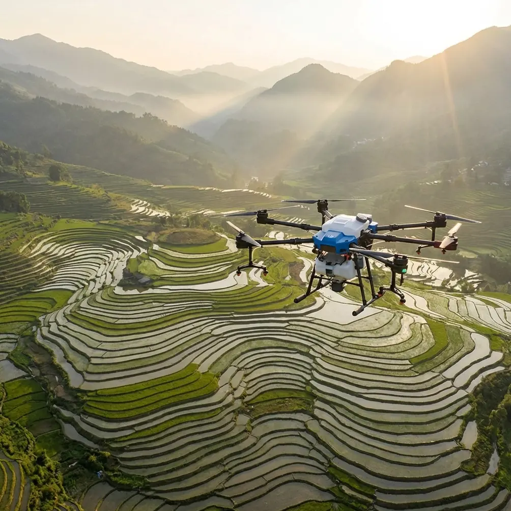
Urban field inspection asks more from an agricultural drone than open-country work ever does. Space is tighter. Surface conditions vary from soft soil to paved edges. Wind behaves badly around buildings. One pass can be routine, and the next can turn complicated because a gust rolls through a narrow corridor between structures. That is where the Agras T100 becomes interesting—not just as a platform for coverage, but as a machine whose real value depends on how well the operator reads flight data, controls rhythm, and adapts when the environment changes mid-mission.
Most discussions about the T100 stop at capability headlines. That misses the part serious operators care about. In urban-adjacent field inspection, the bigger question is this: how does the aircraft behave when things stop being ideal?
The answer starts with two ideas that seem unrelated at first: crash data and control timing.
Why impact data matters even during routine inspection
One of the more revealing reference points comes from a training exercise on measuring drone fall data. In that material, a drone dropped from 80 centimeters recorded a maximum Z-axis acceleration above 4000. That number is not trivia. It tells you how violent even a short drop can be for the airframe, payload mount, sensors, and internal connectors. The same material adds a second operationally useful point: the peak Z-axis impact changes with the ground material, and softer surfaces reduce the maximum value.
For Agras T100 operators inspecting urban fields, that matters in three ways.
First, not all emergency landings are equal. A forced descent onto packed service roads, concrete irrigation edges, or gravel staging areas creates a very different shock profile than a descent onto damp soil or crop residue. If your T100 carries inspection payloads, multispectral modules, or calibration-sensitive components, the choice of recovery zone is not cosmetic. It affects what kind of post-flight checks you need and whether data collected just before the event should be trusted without validation.
Second, raw acceleration data can tell a story after an incident. The source material specifically points to recording TOF height, acceleration, and maximum attitude angle values when propulsion stops and the aircraft falls. On a modern platform like the Agras T100, that kind of sensor trace can help reconstruct whether a mid-flight anomaly began with wind shear, a sudden obstacle-avoidance reaction, a pilot input issue, or a hard surface impact after an otherwise controlled descent.
Third, impact awareness changes how you plan inspection routes in dense environments. Urban field inspection often involves fragmented plots bordered by fences, drainage channels, retaining walls, greenhouse structures, or access roads. If the mission area includes multiple potential touchdown points, the smart operator tags preferred emergency landing zones in advance—not only for clearance, but for surface softness and sensor survivability.
That is one of the practical lessons hidden in what looks like a basic training example. A sub-meter fall producing a four-digit Z-axis spike is a reminder that the T100’s data logs are not just for maintenance teams. They should shape how the mission is designed from the start.
The “black box” mindset belongs in drone operations too
The same reference set draws a line to aviation’s “black box,” noting that these recorders became easier to recover when they were changed from black to bright orange and labeled clearly as flight recorders. That historical detail matters less for color than for philosophy. Civil aviation matured because it learned to treat every anomaly as recoverable evidence.
That same mindset improves Agras T100 operations immediately.
If you are using the drone to inspect urban fields, especially where weather can shift inside a short window, treat the aircraft as a flying data recorder as much as a working platform. Flight logs, RTK fix stability, altitude traces, obstacle alerts, spray system behavior, and nozzle calibration records should not be afterthoughts saved only when something goes wrong. They are operational memory.
This is especially relevant if the T100 is used in a mixed inspection-and-application workflow. A field may begin as a scouting mission, move into canopy assessment, and end with a targeted treatment plan. Without reliable records, it becomes harder to separate crop stress from drift, pilot deviation from wind deviation, or sensor artifacts from real agronomic patterns.
Operators who do this well usually build a simple habit stack:
- verify RTK fix rate before entering the narrowest working section
- confirm nozzle calibration before any spray-enabled pass
- review local surface types for emergency descent planning
- compare post-flight logs with what the operator actually observed in the air
That is not bureaucracy. It is how centimeter-level tools stay useful in messy real conditions.
Mid-flight weather changes are where the T100 earns its keep
On paper, urban field inspection sounds calm. In reality, weather behaves unpredictably near structures. During one representative scenario, the mission begins under steady conditions: acceptable visibility, manageable drift risk, strong RTK lock, and stable swath planning along a compact urban field boundary. Then the wind shifts.
Not a dramatic storm. Just the kind of sharp, uneven airflow that starts when warm pavement, building edges, and open crop rows begin interacting. One moment the T100 is holding a clean line. The next, gusts push across the intended path, and drift risk rises. This is the point where spec-sheet reading stops and aircraft behavior matters.
The Agras T100’s value in that moment is not simply that it can continue flying. It is whether it continues flying predictably enough for the operator to make disciplined decisions.
For inspection work, stable position holding and a strong RTK fix rate reduce the chance that a gust gets misread as a navigation error. Centimeter precision is not just about beautiful path lines on a screen. In urban fields, it helps preserve repeatability when you need to compare one pass against another after conditions change. If a multispectral read on the south edge of a plot appears inconsistent, you need confidence that the aircraft was where it was supposed to be when the image was captured.
If the mission includes application tasks, the weather shift becomes even more sensitive. Spray drift can go from manageable to unacceptable very quickly around walls, low roofs, utility corridors, and roadside vegetation. In that case, nozzle behavior and swath width are no longer routine setup items. They become active risk controls. A well-calibrated system helps ensure that if the operator narrows the working envelope or pauses treatment, the next resumed pass still reflects known output rather than guesswork.
This is where the T100’s weather tolerance and field practicality matter more than slogans. A platform built for agricultural work should not merely survive a changing environment. It should provide enough flight stability, system feedback, and recoverable log data that the operator can decide whether to continue, modify the pattern, or stand down.
That distinction separates professional outcomes from hopeful ones.
Pilot rhythm is underrated in inspection quality
The second reference document comes from aerobatic radio-control training, which might seem far removed from an agricultural aircraft. It is not. One of its strongest ideas is that precision improves when the pilot breaks a maneuver into manageable segments and internalizes the rhythm before trying to correct everything in real time. The example given is an 8-point roll, mentally divided into 1-2-3-4, then 1-2-3-4. The larger lesson is even more useful: complete the action, review the result, then adjust timing on the next attempt rather than chasing every micro-error during the move itself.
That principle transfers directly to Agras T100 field inspection.
In urban plots, a mission often consists of repeated narrow passes with little room for sloppy timing. Operators who over-correct continuously tend to create uneven spacing, inconsistent altitude behavior, and unstable swath overlap. Operators with good rhythm do something different. They commit to a pass, observe how the aircraft tracks through the environment, and then refine the next pass based on the result.
This matters for inspection imagery, for spray consistency, and for safety.
Take a row-edge pass beside a warehouse wall. If the T100 experiences a mild lateral push halfway through, the worst response is a string of hurried inputs that distort the remainder of the route. A better response is to maintain composure, complete the pass within safe bounds, then adjust line entry speed, standoff distance, or control timing before the next run. That is essentially the same training logic described in the reference: rhythm first, reflection next, refinement after.
The source also notes that skilled control depends on recognizing position in sequence rather than improvising at every point. In practical T100 terms, that means the operator should know where the decision gates are before takeoff:
- where to verify crosswind effect
- where to assess drift along the first exposed edge
- where RTK stability typically weakens near structures
- where to shorten swath width if turbulence increases
- where to break off the mission if the pattern stops looking repeatable
That level of structured thinking is what keeps a technical inspection mission from turning into reactive flying.
Urban inspection is not just about seeing the field
The Agras T100 becomes most useful when field inspection is treated as a layered job, not a single camera flight. In compact urban-growing environments, the aircraft may be evaluating crop vigor, checking water stress, validating previous treatment boundaries, and identifying obstacles for later application work. A multispectral workflow can deepen the agronomic picture, but only if the flight path and environmental conditions are controlled tightly enough to trust the comparison.
That brings us back to data traceability.
If a weather shift occurs mid-flight, your inspection record should reflect more than “conditions worsened.” It should show when the RTK behavior changed, whether altitude holding remained consistent, whether the operator modified route geometry, and whether any part of the field should be rescanned for clean comparison. In a professional operation, logs and observations need to align.
The T100’s likely appeal in these environments is not brute force. It is system integration. Precision navigation, robust field handling, and inspection repeatability become more valuable than raw size when plots are constrained and neighboring surfaces amplify operational complexity.
And because urban fields often sit close to infrastructure, durability matters too. A machine built to tolerate harsh farm conditions has a natural advantage when exposed to dust, splash, and repeated setup cycles. That is why ruggedization features such as IPX6K-level resistance matter in the real world. Not because operators plan to abuse the aircraft, but because municipal-edge agriculture is full of hose-down areas, wet access paths, and inconsistent staging conditions.
What a serious T100 operator should take away
The best way to understand the Agras T100 for urban field inspection is to stop thinking only in terms of mission completion and start thinking in terms of mission evidence.
A training document showing more than 4000 in peak Z-axis acceleration from an 80 cm fall tells you that minor-looking incidents can have major mechanical implications. A discussion of aviation flight recorders reminds you that data recovery is part of safe operations, not a luxury. An aerobatic control lesson built around counting rhythm shows why accurate repeated passes come from planned timing and post-pass refinement, not frantic stick corrections.
Put those ideas together, and a clearer picture of the T100 emerges.
It is not just a drone for covering fields. It is a platform that rewards disciplined operators—people who care about nozzle calibration before the first pass, who watch RTK fix rate before entering a difficult corridor, who understand that swath width in gusty urban edges is a dynamic choice, and who can read a flight log after a rough landing instead of guessing what happened.
If you are evaluating how the Agras T100 fits your inspection workflow, especially where urban conditions can change in the middle of the job, the right conversation is a technical one. For field-specific planning or setup questions, you can message Marcus Rodriguez directly here.
The operators who get the most from a platform like this are rarely the ones chasing the biggest headline feature. They are the ones who combine precise hardware with disciplined interpretation: route design, rhythm, environmental judgment, and respect for what the data is saying before, during, and after the flight.
Ready for your own Agras T100? Contact our team for expert consultation.