Agras T100 Monitoring in Remote Fields: Altitude, Accuracy
Agras T100 Monitoring in Remote Fields: Altitude, Accuracy, and What Actually Matters
META: A technical review of how to use the Agras T100 effectively for remote field monitoring, with practical insight on flight altitude, RTK performance, spray drift control, nozzle calibration, and rugged field reliability.
Remote-field work exposes the difference between a drone that looks capable on paper and one that keeps delivering when the nearest road is far behind you. The Agras T100 sits in that second category when it is deployed with discipline. Not just flown. Managed.
For growers, agronomists, and field teams covering distant acreage, the real question is not whether the T100 can operate there. It can. The better question is how to configure it so each sortie produces usable field intelligence without wasting battery cycles, overflying problem zones, or compromising application accuracy when the wind shifts.
That is where setup choices matter more than brochure specs. Flight altitude, RTK fix rate, nozzle calibration, swath width, and environmental sealing all become operational variables. Ignore them and the aircraft becomes inefficient. Get them right and the T100 turns into a practical remote-field platform that can monitor crop conditions, verify treatment coverage, and support decisions where walking the field would take half a day.
Why the T100 fits remote-field operations
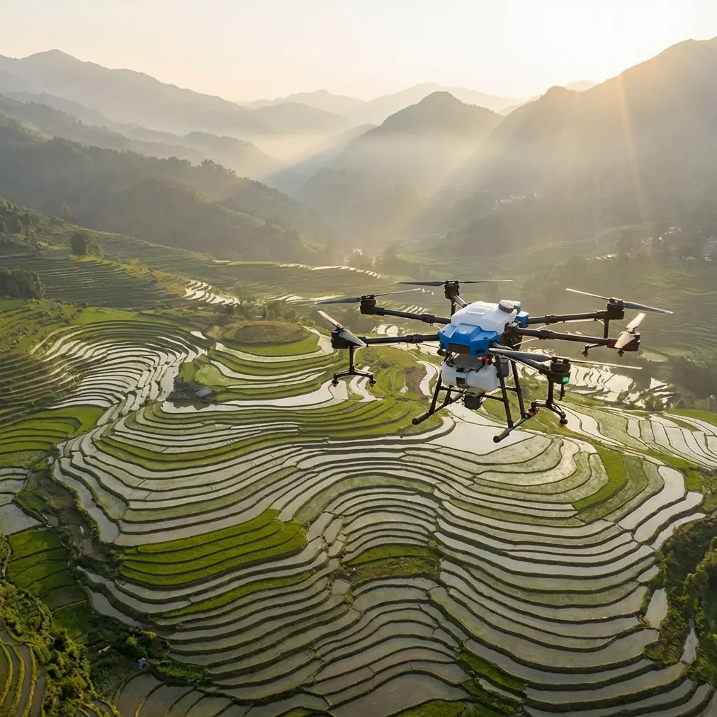
The Agras T100 makes the most sense in large or hard-to-reach blocks where consistency matters more than improvisation. Remote fields tend to create the same operational pattern: rough access, inconsistent terrain, limited support equipment on site, and a strong need to collect actionable information in fewer passes.
That is why two details matter immediately.
First, centimeter precision. In remote fields, the value of high-accuracy positioning is not abstract. It reduces overlap, keeps pass-to-pass tracking tight, and gives the operator cleaner records when returning to the same block after weather or treatment delays. If your field edge is irregular, bordered by drainage lines, or interrupted by tree belts, centimeter-level positioning helps the aircraft hold intended paths instead of slowly drifting into wasted coverage.
Second, IPX6K-level protection. Remote work punishes equipment. Dust, residue, splash exposure, and the simple reality of setting up in less-than-ideal conditions all add up. A machine with strong ingress protection is not just easier to clean. It is more realistic for operations where you may run several missions before returning to a controlled work area.
Those two details alone tell you a lot about how the T100 should be evaluated: not as a neat piece of technology, but as a field tool built for repeated use under variable conditions.
The best flight altitude for monitoring remote fields
If your purpose is monitoring rather than broad, generalized surveying, the optimal flight altitude is usually lower than many operators first assume.
For the Agras T100 in remote-field monitoring, a working altitude around 3 to 5 meters above canopy is often the most useful starting range when the objective is operational inspection tied to treatment quality, crop uniformity, and localized problem detection. That range tends to balance three competing needs:
- enough proximity to read canopy behavior and treatment response,
- enough separation to maintain stable tracking over uneven crop surfaces,
- and enough margin to avoid rotor wash becoming part of the problem.
Why not fly higher? Because the farther you move from the crop surface, the more likely you are to lose the fine visual and pattern-level cues that matter in remote management. Gaps in emergence, lodging edges, missed strips, uneven deposition zones, and early stress signatures become harder to interpret if altitude is chosen purely for speed.
Why not fly lower than 3 meters by default? Because remote fields are rarely uniform. Small canopy height changes, hidden rises, crop edge transitions, and wind shear near the surface can force unnecessary corrections. That introduces instability right when you want smooth, repeatable data capture.
The practical answer is not a single universal altitude. It is a disciplined range, then adjustment. Start near 4 meters above canopy, review image quality and path stability, then tune up or down based on terrain roughness, crop density, and the purpose of the mission.
For example:
- If you are checking for missed application bands or edge-of-pass inconsistency, staying closer to 3 to 4 meters improves local detail.
- If you are covering a larger remote block and need broader pattern recognition first, moving toward 5 meters may improve efficiency without sacrificing too much interpretability.
- If wind is building, it is usually better to preserve aircraft stability and reduce drift effects through careful altitude adjustment than to force a low pass that degrades data quality.
That altitude discipline becomes even more important when treatment verification and monitoring are happening in the same operational window.
Spray drift is not just an application problem
One of the easiest mistakes in remote operations is treating monitoring and application as separate conversations. In practice, they overlap.
Agras users often focus on spray drift only during active application, but drift control also affects what you see when reviewing field results. If droplets move off target, your monitoring pass can mislead you. You may interpret weak efficacy as a nozzle issue, a crop health issue, or a route-planning mistake when the main cause was drift under unsuitable flight height or wind conditions.
That is why monitoring missions linked to spray work should be flown with the application profile in mind. Swath width may look acceptable in ideal conditions, but drift can distort actual field outcomes long before it becomes visually obvious from the air.
The T100’s usefulness in this context depends on disciplined operating habits:
- verify nozzle calibration before the sortie sequence,
- confirm the intended swath width against field conditions rather than assuming the nominal pattern holds,
- and use repeatable route geometry so any inconsistency can be traced to environment or hardware, not operator variation.
Nozzle calibration deserves more respect than it usually gets. In remote fields, a small calibration error can go undetected for longer simply because ground verification takes more effort. By the time a problem is noticed, an entire block may have been treated unevenly. Calibration is therefore not a maintenance checkbox. It is part of data integrity.
If you monitor after application, that calibration work directly improves interpretation. Uneven crop response is far easier to diagnose when the application system was verified beforehand.
RTK fix rate decides whether your maps are trustworthy
Many operators talk about RTK as though it is merely a premium accuracy feature. In remote fields, the RTK fix rate is closer to a confidence score for your entire mission.
A stable fix helps the T100 maintain repeatable tracks, especially on long lanes where tiny path deviations accumulate into meaningful overlap or skipped areas. For monitoring, that means cleaner comparisons between flights. For treatment-related operations, it means more reliable placement relative to field boundaries and previously flown lines.
The operational significance is simple: if the RTK fix rate is inconsistent, your field history becomes fuzzy. You can still fly. You just cannot trust the outputs as much.
That matters in three remote-field situations:
- Return inspections: you revisit the same stress patch after rain, fertilizer application, or pest pressure.
- Boundary-sensitive flying: you work near waterways, shelterbelts, roads, or neighboring crops.
- Patch treatment review: you compare what was intended with what was actually covered.
Centimeter precision only helps if the positioning solution is being held consistently. A poor RTK state can make a neat mission log look more authoritative than it really is.
Before launching into a remote block, check fix stability, not just initial lock. A momentary good status on the ground is less valuable than a sustained, stable solution through the route.
Multispectral value depends on the mission question
The mention of multispectral capability often attracts attention because it sounds advanced. The real issue is whether it answers a field question you actually have.
In remote acreage, multispectral workflows can be useful when visual inspection alone cannot separate stress causes early enough. That could mean distinguishing moisture-related variability from a treatment gap, or spotting subtle canopy changes before they are obvious in standard imagery. But the tool only earns its place if the data leads to a decision.
For Agras T100 operators, the best use of multispectral-linked thinking is not chasing abstract vegetation maps. It is narrowing the search area. In remote fields, time on site is expensive in every practical sense. If multispectral analysis helps reduce a 50-hectare uncertainty zone to a 5-hectare inspection target, it has done valuable work.
The point is not to overcomplicate the mission stack. It is to use remote sensing selectively, then let the T100 support targeted follow-up with accurate low-altitude flight and repeatable field access.
Swath width: useful metric, dangerous assumption
Swath width gets repeated often because it is measurable and easy to compare. Yet in actual remote-field use, it is one of the most misused numbers.
A swath that looks efficient on a planning screen may fail under canopy variability, light crosswind, uneven pressure, or small altitude deviations. The result is not always obvious from the operator’s live view. You may finish the block thinking efficiency was high when uniformity was only average.
That is why swath width should be treated as a validated field number, not a fixed truth. On the T100, the right swath is the one that holds under the specific crop and weather conditions that day.
This loops back to altitude. Raise the aircraft too far and the pattern can become less consistent where drift risk is present. Fly too low and turbulence effects can complicate deposition and route smoothness. In remote blocks, where rework is costly, the best operators give up a little theoretical speed to preserve repeatable coverage.
That tradeoff usually pays for itself.
Ruggedness is operational efficiency
IPX6K protection may not seem exciting compared with flight and sensor specs, but in remote work it becomes a force multiplier. A drone that tolerates harsh cleanup, splashing, and dirty staging conditions shortens turnaround friction. It also lowers the chance that a minor contamination issue ends the day early.
That matters more than many teams admit. Remote-field productivity is often limited by logistics, not just battery capacity. Every interruption costs time: cleaning, troubleshooting, checking connectors, or relocating because the launch area is poor.
A rugged airframe does not remove the need for proper maintenance. It simply gives the operator a wider margin when real field conditions are less tidy than planned.
If your team is building a remote monitoring workflow around the T100, durability should be viewed as mission continuity, not convenience.
A practical setup for remote monitoring with the T100
For most field teams, a strong baseline workflow looks like this:
Begin with route planning designed around repeatability, not maximum area per sortie. Confirm RTK stability before committing to a long pass sequence. Set initial monitoring altitude near 4 meters above canopy and adjust only after reviewing terrain and image usefulness. Validate nozzle calibration if the aircraft is also being used in treatment-related operations. Then confirm real-world swath behavior instead of relying on planning defaults.
That combination produces cleaner comparisons over time and makes anomalies easier to diagnose. If a result changes, you can isolate whether the cause was crop condition, weather, or machine setup.
Remote-field operations reward routines that remove uncertainty.
If you want a field-specific setup discussion, you can reach out through this direct Agras planning chat: https://wa.me/example
Final assessment
The Agras T100 is most compelling in remote monitoring when it is treated as a precision field system rather than a simple spray platform. Its value comes from the interaction of several things at once: centimeter precision for repeatable routes, RTK fix stability for trustworthy positioning, IPX6K durability for real-world deployment, and disciplined control of altitude, drift, calibration, and swath width.
If there is one operating insight to keep front and center, it is this: for remote-field monitoring, start around 3 to 5 meters above canopy, with 4 meters as the best default reference point. That range usually gives the clearest balance between detail, aircraft stability, and practical coverage. Everything else should be tuned around that baseline.
Teams that get this right do not just collect more data. They collect field evidence they can actually use.
Ready for your own Agras T100? Contact our team for expert consultation.