Monitoring Urban-Edge Fields With the Agras T100
Monitoring Urban-Edge Fields With the Agras T100: What “Multi-Angle Data” Really Changes in Daily Work
META: A practical expert look at monitoring urban fields with the Agras T100, using DJI’s latest multi-angle aerial operations theme to improve precision, drift control, and access in hard-to-reach plots.
Urban agriculture has a visibility problem.
Not because the crops are invisible, but because the fields themselves are awkward. They sit behind warehouses, beside ring roads, next to drainage corridors, under utility setbacks, and in fragmented plots that never behave like clean textbook rectangles. You can stand at ground level and still miss half of what matters. Irrigation leaks hide behind embankments. Stress patterns form along fence lines. Spray drift risk changes from one edge of the block to another because one side faces a traffic corridor and the other backs into mixed vegetation.
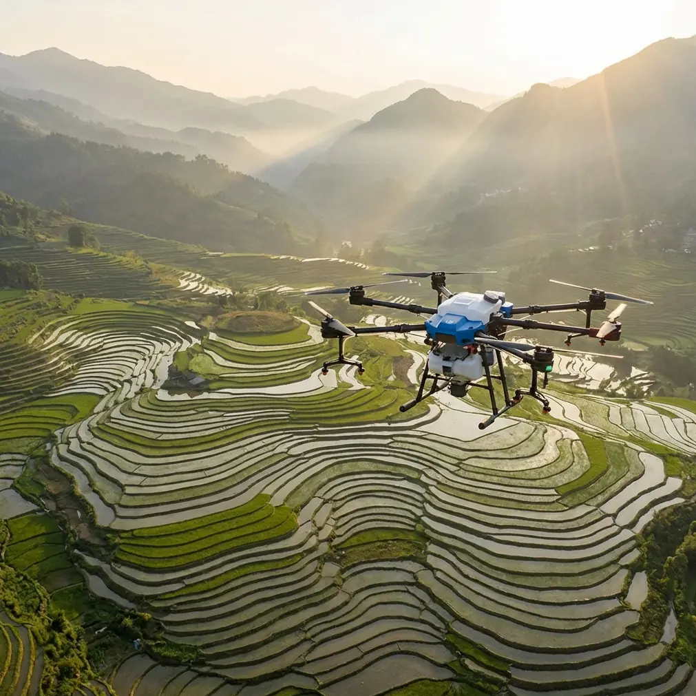
That is where the Agras T100 becomes more interesting than a simple “farm drone” label suggests.
The useful lens here comes from DJI’s January 8, 2025 announcement of the Matrice 4 Series. The message was brief, but the ideas behind it were sharp: aerial tools for daily tasks, the ability to gather data from multiple angles, and practical use in less-traveled or hard-to-reach areas. Those are not abstract marketing themes. In urban-edge field monitoring, they describe the exact operational gap many growers and service providers are trying to close.
The T100’s role in that gap is not just to cover acres. It is to make messy, constrained, obstacle-heavy field intelligence usable on a normal workday.
The real problem with urban field monitoring
Most field monitoring systems are designed around open-space assumptions. You have broad access. You can walk or drive perimeter lines. You can maintain line-of-sight to crop issues. You can inspect trouble spots without crossing drainage channels, private boundaries, roadside hazards, or overgrown margins.
Urban agriculture breaks those assumptions fast.
A small field near a logistics park may have three different microclimates in one parcel. Heat radiates off concrete. Wind curls around buildings. Shadows from infrastructure delay drying in one corner and intensify disease pressure in another. A canal or service road might cut off direct access to a weak area. Add a narrow operating window, and the monitoring plan collapses into guesswork.
This is why DJI’s emphasis on everyday aerial work matters. Not occasional scouting. Not one dramatic mission per season. Daily tasks. Repeated, practical, consistent observation.
The Agras T100 fits that reality when it is treated as part of a routine monitoring system rather than just a response tool. In urban settings, you rarely win by flying once and collecting a pretty map. You win by building repeatable visibility over irregular terrain and infrastructure clutter, then linking that visibility to actual field decisions: nozzle calibration, spray timing, edge-zone application rates, re-entry planning, and drift reduction.
Why multi-angle data matters more in city-adjacent plots
The Matrice 4 Series launch highlighted one phrase that deserves more attention than it usually gets: gather data from multiple angles.
For urban fields, that matters because straight-down visual information often tells only part of the story.
A top-down pass can show thinning canopy or uneven vigor. But urban-edge fields often present problems that become obvious only when viewed from oblique perspectives. Tilted views reveal how road embankments are affecting runoff. Side perspectives expose tree-line shading. Structure-adjacent crop rows can look fine from overhead and still be underperforming because airflow is blocked along a retaining wall. If you are working around greenhouses, sheds, sound barriers, or utility corridors, angle diversity is not a luxury. It is the difference between seeing crop symptoms and understanding their cause.
That same logic carries over when a T100 operator plans treatment or follow-up inspection. Multi-angle aerial data can sharpen decisions around swath width, especially near field edges where obstacles or non-crop zones force you to tighten operational margins. It also improves the operator’s confidence when verifying whether a suspected issue is crop stress, shadow effect, access damage, or simply a perspective error from a single overhead capture.
When people talk about precision in agriculture, they often jump directly to centimeter precision and RTK fix rate. Those are valid metrics. But precision starts earlier, with interpretation. If the data angle is wrong, high positional accuracy just lets you be precisely mistaken.
Hard-to-reach areas are not a niche issue
DJI also framed the Matrice 4 Series for roads less traveled and hard-to-reach places. Again, that sounds broad until you apply it to field monitoring in built-up areas.
Some of the most operationally significant zones in urban farming are the least accessible ones:
- rear corners behind fences
- strips near stormwater channels
- field edges bordered by mixed scrub
- narrow patches behind storage yards
- plots hemmed in by roads or rail margins
Those are exactly the areas where weed pressure, standing water, pest movement, and drift-sensitive boundaries tend to concentrate.
On foot, they are slow to inspect. With a utility vehicle, they may be inaccessible or unsafe. With a conventional observation pattern, they are easy to postpone. And the problem with postponing edge-zone monitoring is that edge zones are often where compliance risk and crop loss start.
The T100 changes the rhythm of that work. A consultant or operator can inspect and respond without physically entering every difficult segment. In practice, that lowers the threshold for checking problem spots early instead of waiting until damage is visible from a lane or headland.
That kind of routine matters far more than people admit. In urban field operations, efficiency is not only about covering space. It is about reducing the number of unknowns around constrained areas.
A wildlife moment that changes the mission
On one urban-edge vegetable block I assessed, a sensor-guided flight path had to adjust around an unexpected wildlife encounter: a grey heron stepping out from a drainage margin into a low wet patch near the crop boundary.
That detail may sound minor. It was not.
The bird appeared exactly where a ground team would have had limited visibility due to reeds, uneven bank slope, and a fence line. A rigid, purely route-driven operation could have turned a simple monitoring run into an avoidable disturbance event. Instead, the sensors navigated the situation cleanly, preserving the inspection while avoiding the animal and the unstable margin around it.
This is one reason “intelligence” in aerial operations should be judged by field behavior, not by slogans. In urban agriculture, the environment is layered. It includes crops, hard infrastructure, drainage, traffic-adjacent edges, pedestrians in neighboring areas, and wildlife adapting to fragmented spaces. Monitoring tools have to work inside that complexity.
The significance for T100 users is straightforward: intelligent sensing is not just about obstacle avoidance in the abstract. It directly improves mission continuity in the kind of edge cases that happen all the time near urban plots.
Where the Agras T100 becomes operationally stronger
The T100 is most effective in urban monitoring when operators stop separating scouting from application logic.
A monitoring pass should inform treatment constraints immediately. If the data shows vulnerable edges near roads, your next question is spray drift. If a shaded strip is lagging, the next question may be whether coverage or water retention is uneven. If access to a rear section is poor, then route planning and refill efficiency matter as much as diagnosis.
This is where several technical concepts become practical rather than buzzwords.
Spray drift is not a side topic
Urban fields often sit close to roads, walls, residential buffers, commercial lots, or public walkways. That means drift management is central, not optional. Monitoring data helps define where airflow behaves unpredictably and where treatment passes should be adjusted. The T100’s value increases when image review and application planning are treated as one workflow.
A field may be healthy in the center and sensitive at the edges. Without detailed aerial review, operators tend to use broad assumptions. With better visibility, they can plan edge behavior more carefully and avoid overconfidence in uniform passes.
Nozzle calibration depends on what the field actually looks like
Nozzle calibration sounds like workshop work. In urban-edge farming, it is also reconnaissance work. If the crop architecture changes along retaining walls, drainage cuts, or shaded boundaries, then the ideal output pattern may shift with it. The monitoring mission identifies where canopy density, exposure, and row health stop being uniform.
That is the point: calibration should not be static if the field environment is dynamic.
RTK fix rate and centimeter precision only matter if they support repeatability
Everyone likes to cite centimeter precision. Fair enough. In fragmented urban plots, repeatability really does matter. When operators need to revisit a narrow strip between a fence and a ditch, or document a recurring stress area beside a paved surface, positional consistency saves time and reduces ambiguity.
But the deeper value of a strong RTK fix rate is not the number itself. It is the ability to compare the same problem zone over multiple flights and make decisions with confidence. If one corner repeatedly underperforms, you want to know whether it is a nutrient issue, drainage issue, heat reflection pattern, or edge disturbance. Repeatable location control helps isolate the pattern instead of chasing noise.
Why “daily tasks” is the most overlooked detail
The DJI announcement described aerial tools for daily tasks. That phrase deserves to be underlined because it reframes how operators should deploy the T100 in urban agriculture.
A lot of drone programs fail because they are treated as event-based. Fly when there is a visible issue. Fly when someone complains. Fly after damage has already spread.
That is backward.
Daily-task logic means using the drone to reduce uncertainty before small issues become expensive ones. It means checking the hard-to-reach rear corner because access is difficult, not despite it. It means collecting enough multi-angle information to distinguish a drainage problem from a canopy illusion. It means using flight data to improve the next operation, not just document the last one.
This is especially valuable in urban scenarios because conditions shift quickly. Construction nearby can alter dust and airflow. Traffic patterns can affect field-edge exposure. Temporary obstructions appear. Water movement changes after municipal maintenance or storms. A field that looked straightforward last week can behave differently this week.
The T100, used properly, supports a more disciplined cycle: inspect, interpret, adjust, verify.
A practical urban workflow for the T100
For consultants, growers, and service providers, the strongest approach is usually a problem-solution loop rather than a one-off mission.
Problem: fragmented field geometry and blind spots create uncertainty.
Solution: run regular aerial monitoring with attention to edges, drainage lines, and obstacle-adjacent zones.
Problem: overhead-only views flatten the field’s real conditions.
Solution: incorporate multi-angle data where possible to reveal shading, slope interaction, and structure effects.
Problem: access limitations delay inspection of the most sensitive areas.
Solution: use the drone to check hard-to-reach sections early and often.
Problem: application risk rises near roads, vegetation margins, and built surfaces.
Solution: connect monitoring directly to spray drift planning, swath width adjustments, and nozzle calibration decisions.
Problem: recurring stress zones are hard to compare over time.
Solution: use repeatable positioning and disciplined revisit patterns to build a usable history.
That is not theory. It is the difference between using an advanced drone as a flying camera and using it as a field management instrument.
If you are comparing workflows for an urban deployment, a direct message can save a lot of trial and error; I usually suggest starting here: send a quick field layout note.
The bigger shift behind the Matrice 4 message
Even though the January 2025 announcement was about the Matrice 4 Series, the strategic signal extends beyond one airframe. DJI is clearly emphasizing practical aerial intelligence for routine operations, multi-angle data capture, and work in places that are inconvenient, overlooked, or physically constrained.
That direction matters for Agras T100 users because urban agriculture is full of exactly those conditions.
The future advantage will not belong to operators who simply fly farther or faster. It will belong to those who can turn difficult plots into measurable, repeatable workflows. The less-traveled edge of a field is often where the most expensive surprises begin. The right aerial system helps you get there without delay, see it from more than one perspective, and respond before the issue migrates into the rest of the block.
For urban field monitoring, that is the real promise. Not spectacle. Not novelty. Better decisions in the places that usually resist inspection.
And that is where the Agras T100 earns its place.
Ready for your own Agras T100? Contact our team for expert consultation.