Agras T100 in Windy Solar Farm Monitoring
Agras T100 in Windy Solar Farm Monitoring: A Field Case Study on Stable Data, Mid-Flight Weather Shifts, and Why Precision Still Matters
META: A consultant-led case study on using the Agras T100 for windy solar farm monitoring, with lessons on stability, centimeter precision, RTK fix rate, swath planning, and weather-driven field decisions.
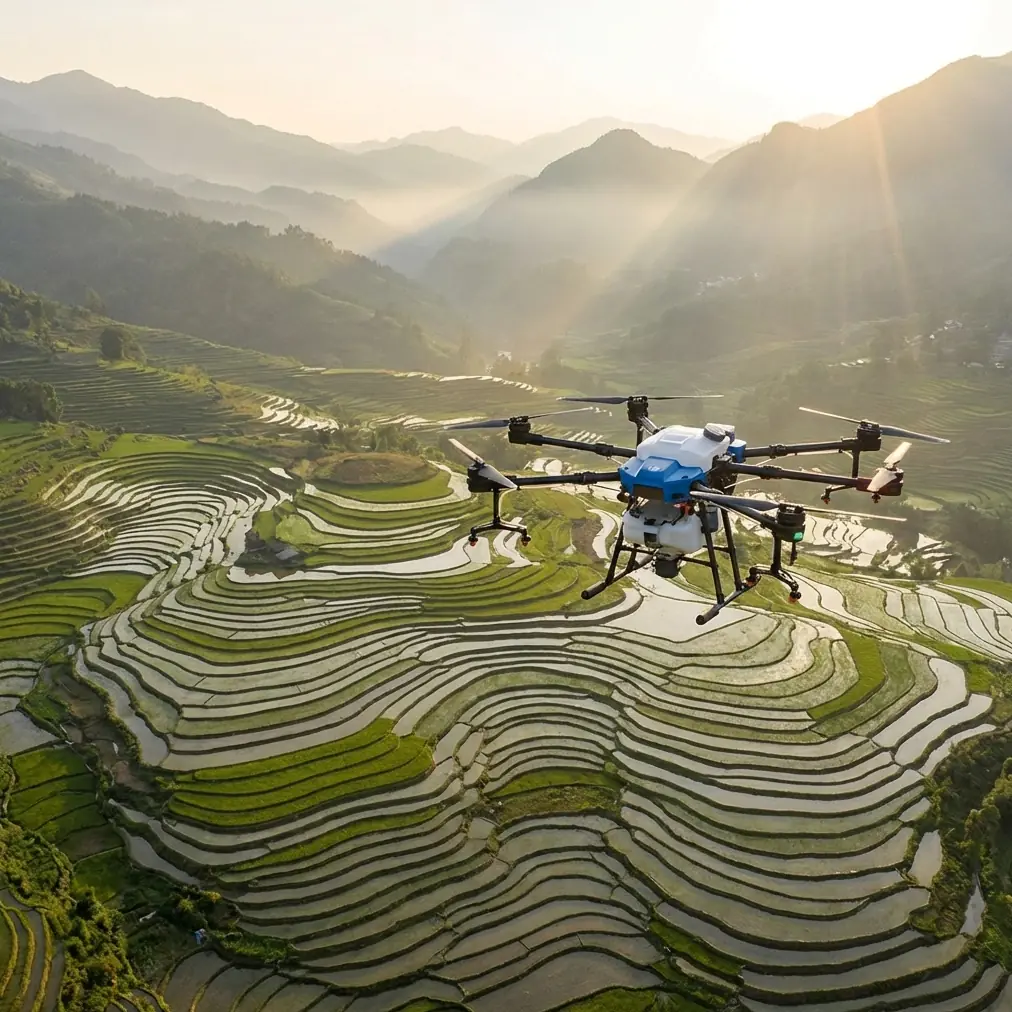
Solar farms look orderly from the access road. Long rows. Predictable geometry. Clean lines. From the air, they are far less forgiving.
That gap between appearance and reality is where the Agras T100 becomes interesting.
I’ve spent enough time around utility-scale sites to know that wind changes everything. A solar farm can be calm at the operations trailer and turbulent above the panel rows. Air spills over embankments, funnels down maintenance corridors, and lifts off the hotter sections of the array. If your mission depends on reliable, repeatable aerial data, that matters more than most spec sheets admit.
This case study looks at how the Agras T100 fits a very specific job: monitoring a solar farm in windy conditions. Not generic “inspection.” Not broad platform hype. A real operational scenario shaped by changing weather, RTK performance, route discipline, and the need to produce usable outputs for maintenance planning.
What makes this worth discussing now is not only the aircraft. It is the wider shift in how drone data is being used. A useful comparison comes from outside energy and straight from city operations. In London, the Borough of Harrow recently expanded its digital twin using high-resolution drone imagery combined with existing lower-resolution datasets. The point was practical, not cosmetic: improve maintenance, support planning, and strengthen public engagement, while reducing maintenance costs and improving services.
That same logic carries directly into solar operations. High-resolution aerial capture is no longer just about finding an issue. It is about feeding a working model that helps teams decide what to fix first, how to schedule crews, and how to avoid repeated site visits.
The site and the problem
The site in question was a large solar installation with long panel blocks, perimeter roads, inverter stations, drainage features, and a few exposed sections where crosswinds tend to build by late morning. The monitoring goal was straightforward: generate a current, positionally reliable visual record of the array and support maintenance review after a period of unsettled weather.
The catch was the forecast. Conditions were flyable at launch, but the models showed a likely wind increase during the mission window.
That is a familiar pressure point for field teams. Delay too long and the light changes, crews move into the work zone, or the schedule slips. Launch too early without a disciplined plan and you end up with uneven coverage, weak overlap, or positional inconsistency that ruins change detection later.
The Agras T100 was selected because the job required more than basic flight endurance. It needed predictable route holding, a strong RTK fix rate, and stable behavior when the weather stopped cooperating.
Why centimeter precision matters on a solar farm
People often hear “centimeter precision” and immediately think surveying. That is only part of the story.
On a solar site, positional precision affects maintenance decisions in very practical ways. If you identify a pattern of debris accumulation, suspected panel discoloration, vegetation encroachment, standing water near a support area, or access-road degradation, the value of the image depends on whether the operations team can locate the issue quickly and trust the mapping alignment.
This is where RTK fix rate stops being a technical vanity metric and starts becoming an operational one. A strong, stable fix rate improves confidence that repeat missions line up properly over time. That means less guesswork when comparing one flight to the next, especially after storms, high winds, or maintenance activity.
For windy-site monitoring, repeatability is often more valuable than raw speed. A drone that finishes fast but gives you inconsistent spatial outputs creates more downstream friction than a slower mission with dependable data alignment.
Mid-flight, the weather changed
About a third of the way through the mission, the wind shifted.
Not dramatically at first. The early sign was subtle: slight correction behavior on the cross-row legs and a small but noticeable change in groundspeed consistency. Then the gusts became more organized. You could see it in the vegetation near the service track, and you could feel it in the way the aircraft had to work across the open sections of the array.
This is the moment where poor planning shows up.
If the route is not built with realistic swath width assumptions, the temptation is to keep pushing and hope the overlap remains acceptable. That is how operators end up with stitched products that look fine at a glance but fail under maintenance review because edge detail becomes unreliable or row-to-row consistency breaks down.
With the T100, the response was not brute force. It was discipline. We adjusted the mission logic around the wind rather than pretending the original assumptions still held. Swath width was treated conservatively to protect coverage quality, and flight lines were managed with repeatability in mind rather than maximum area per battery cycle.
That distinction matters. In windy conditions, aggressive swath planning may save time in the air and cost time in the office. If your final deliverable has coverage gaps, blurred edge features, or weak alignment, the field shortcut was not a shortcut.
Stability is not just about staying airborne
There is a low standard for the word “stable” in drone talk. Many aircraft are called stable because they do not do anything alarming. That is not enough for infrastructure monitoring.
For solar farm work, stability means the platform can preserve useful image capture conditions while making constant small corrections in a disturbed air environment. It means route fidelity remains high enough that data products are still trusted after processing. And it means the aircraft behavior does not force the operator into reactive decision-making every few seconds.
The Agras T100 handled the changing conditions the way you want a work platform to handle them: with predictability.
That predictability reduced workload. It also preserved decision quality. Instead of spending the whole second half of the mission fighting the aircraft, we were able to pay attention to the outputs that actually matter: row consistency, edge clarity, positional confidence, and whether the site model would still support maintenance review afterward.
Lessons from Harrow’s digital twin apply here
The Harrow example is useful because it proves a broader point. Their expanded digital twin was built by combining high-resolution drone imagery with lower-resolution existing data. That blend improved maintenance, planning, and public engagement, and the reported result was lower maintenance cost and better public services.
Translate that to a solar farm and the pattern is obvious.
A drone mission should not be treated as an isolated visual exercise. The higher-value move is to merge fresh, high-resolution aerial capture with the site’s existing operational layers: asset maps, panel block layouts, prior inspection records, drainage history, vegetation management zones, and maintenance logs.
When you do that well, the drone stops being “the thing that collected images” and becomes part of a site intelligence workflow.
That is exactly why precision and consistency matter on a windy day. If the new data layer cannot align cleanly with existing lower-resolution site information, you lose the advantage Harrow demonstrated so clearly. The benefit comes from the combination. High-resolution drone capture supplies the current detail; legacy layers provide context. Together, they support better decisions.
What the T100 did well in this scenario
The strongest performance point was not flashy. It was composure.
The aircraft maintained usable mission integrity even after conditions degraded mid-flight. That gave us enough confidence to complete priority coverage rather than aborting at the first sign of instability. For operators working large commercial sites, that is significant. Lost missions are expensive in ways people rarely calculate properly. It is not just battery time. It is crew scheduling, access coordination, weather windows, site permissions, and reporting delays.
A few specific operational takeaways stood out:
1. RTK discipline paid off
On solar assets, a healthy RTK fix rate is one of the easiest ways to protect the downstream value of your data. In this case, it supported repeatable positioning when the wind began pushing the aircraft harder on cross-track segments. That reduced the risk of a visually acceptable but analytically weak result.
2. Conservative swath width protected the mission
Wider is not always better. In shifting wind, swath width should be planned around actual conditions, not idealized coverage claims. Protecting overlap and image consistency kept the dataset useful for maintenance review.
3. Wind changed the flight, not the objective
This is a subtle but important distinction. The mission parameters adapted. The inspection intent did not. The goal remained the same: produce a reliable, actionable site record. The T100 gave enough control margin to make those adjustments without turning the sortie into guesswork.
A word on spray drift, even in a monitoring discussion
The T100 sits in a product family associated with field application work, so terms like spray drift and nozzle calibration naturally come up. On a solar monitoring mission, those are not active flight tasks, but they still reveal something valuable about the platform mindset.
Spray drift is really a lesson in wind respect. Nozzle calibration is really a lesson in system accuracy and repeatable output. Those habits carry over into monitoring. Operators who understand drift risk tend to be better at route planning in gusty environments. Teams that care about calibration tend to care about data integrity.
So even in a non-application mission, those concepts matter indirectly. They shape how seriously you treat weather, spacing, speed, and consistency.
IPX6K and field reality
A windy solar site is often a dirty one. Dust, fine debris, sudden moisture, and regular washdown expectations are all part of the environment. That is why ingress protection is not a throwaway spec. An IPX6K-rated system signals a platform built with harsher field conditions in mind, which is relevant when your aircraft is expected to work near exposed infrastructure rather than from a pristine test pad.
No aircraft becomes invincible because of a protection rating. But in real field operations, robustness influences confidence, turnaround, and maintenance planning. Equipment that fits the environment tends to get used more intelligently because teams trust it enough to deploy it when conditions are imperfect, but still workable.
Multispectral expectations
Could multispectral add value on a solar site? Sometimes, depending on the maintenance objective and sensor stack involved. But it should not be inserted as a buzzword.
For this mission, the core requirement was high-confidence visual monitoring and positional reliability in wind. That is the lesson. Extra layers only help if the foundational capture is stable. A weakly aligned multispectral dataset is still weakly aligned.
The Harrow digital twin example reinforces that. The value came from high-resolution drone imagery being integrated meaningfully with other data sources. Better detail only matters when it can be used.
The real result
The mission produced what the maintenance team actually needed: current, trustworthy aerial context tied closely enough to site geography to support action.
That sounds simple. It is not.
A lot of drone missions create impressive-looking outputs that do little to shorten the path between observation and maintenance. This one did, largely because the T100 held up when the weather shifted and because the operational plan respected the conditions instead of denying them.
For teams building recurring monitoring programs, that is the bigger takeaway. Wind resistance is only part of the story. The larger question is whether the aircraft helps you create data that can be layered into a living operational model, the same way Harrow used high-resolution drone imagery to strengthen a broader city dataset for planning and maintenance.
Solar farms deserve the same maturity. Not random flights. Not disconnected imagery. A structured record that improves service decisions over time.
If you are planning a windy-site workflow and want to compare route design, RTK setup, or panel-row coverage strategy, you can message Marcus directly here: https://wa.me/85255379740
The Agras T100 proved something useful on this job. Not that it can fly in wind. Many drones can, at least for a while. The real point is that it remained a productive tool after the weather changed, and that is what separates a platform that gathers footage from one that supports operations.
Ready for your own Agras T100? Contact our team for expert consultation.