T100 Vineyard Scouting at Altitude: Expert Guide
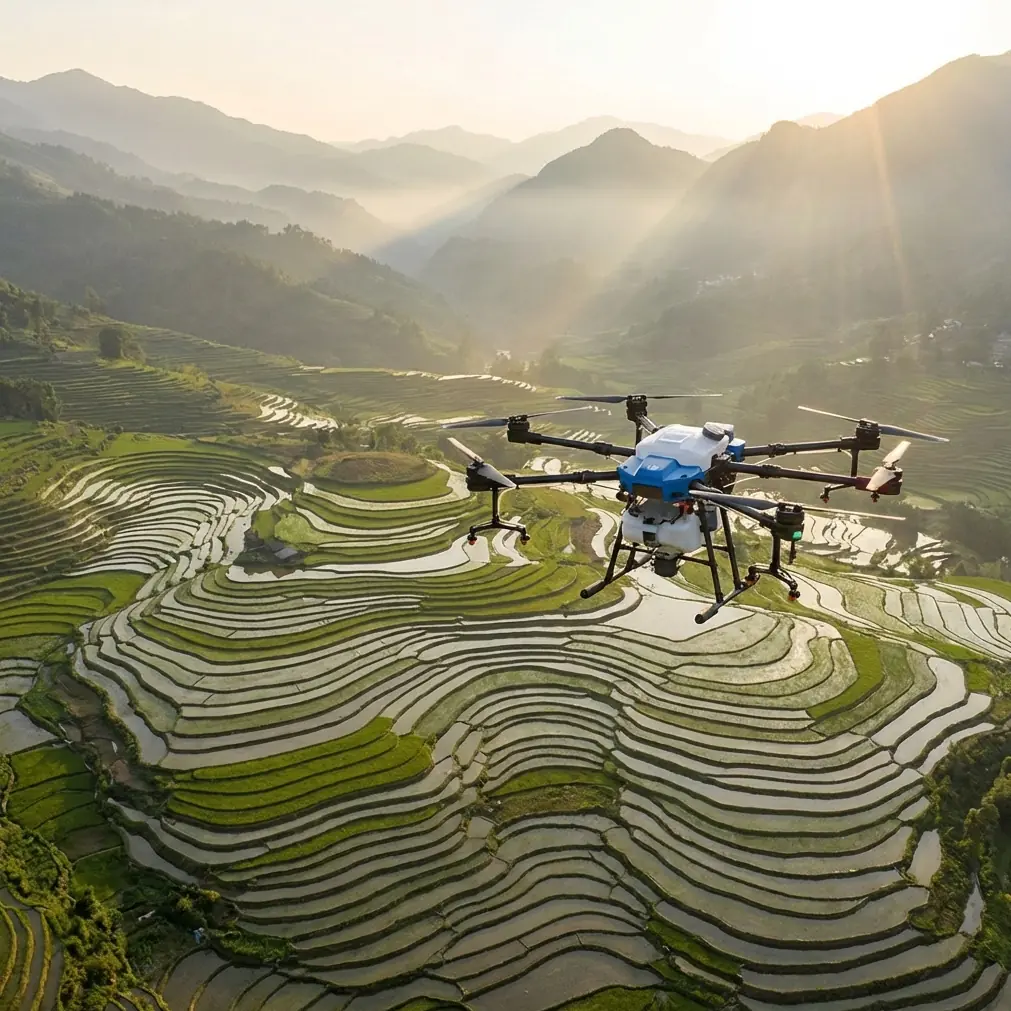
T100 Vineyard Scouting at Altitude: Expert Guide
META: Master high-altitude vineyard scouting with the Agras T100. Learn expert techniques for precision agriculture in challenging mountain terrain conditions.
TL;DR
- RTK Fix rate above 95% ensures centimeter precision even at elevations exceeding 2,000 meters
- IPX6K rating protects against sudden mountain weather shifts during critical scouting missions
- Multispectral integration detects vine stress patterns invisible to standard RGB cameras
- Proper nozzle calibration at altitude prevents costly spray drift in sloped vineyard blocks
The High-Altitude Vineyard Challenge
Mountain vineyards produce exceptional wines. They also create exceptional headaches for precision agriculture teams.
Thin air reduces lift efficiency. Unpredictable weather windows shrink operational time. Steep terrain makes traditional ground scouting dangerous and incomplete.
The Agras T100 addresses these specific challenges with engineering designed for exactly these conditions. This guide breaks down the techniques, settings, and strategies that transform high-altitude vineyard scouting from a gamble into a reliable operation.
Understanding Altitude's Impact on Drone Operations
Air density drops approximately 3% per 300 meters of elevation gain. At 1,500 meters, your drone works noticeably harder. At 2,500 meters, improper configuration leads to mission failures.
The T100's propulsion system compensates automatically, but operators must understand the underlying physics.
Key Altitude Considerations
- Reduced hover efficiency requires larger battery reserves
- Thinner air affects spray patterns and droplet behavior
- GPS signal quality often improves at elevation due to reduced interference
- Temperature swings between morning and afternoon exceed 15°C regularly
Expert Insight: Plan high-altitude missions for the two hours after sunrise. Thermal stability peaks during this window, and battery performance remains optimal in cooler temperatures.
Pre-Flight Configuration for Mountain Vineyards
Standard lowland settings fail in mountain environments. The T100 requires specific adjustments before every high-altitude deployment.
RTK Base Station Placement
Position your base station on stable ground with clear sky visibility. Mountain terrain creates multipath interference when signals bounce off rock faces.
Achieve RTK Fix rate above 95% before launching. Anything lower compromises the centimeter precision required for row-accurate scouting passes.
Swath Width Adjustments
Reduce your planned swath width by 10-15% compared to sea-level operations. Thinner air creates wider spray drift patterns, and overlapping coverage prevents gaps in data collection.
The T100's planning software accepts manual swath overrides. Use them.
Battery Management Protocol
- Charge batteries to 100% the night before
- Store at 20-25°C until flight time
- Plan missions using 70% of rated capacity as your operational ceiling
- Carry minimum two backup sets for full vineyard coverage
Multispectral Scouting: Beyond Visual Assessment
Human eyes miss early vine stress. By the time leaves yellow visibly, intervention windows have closed.
The T100's multispectral payload captures NDVI, NDRE, and thermal data simultaneously. This combination reveals:
- Water stress patterns two weeks before visual symptoms
- Nutrient deficiency zones requiring targeted fertilization
- Disease pressure areas for early fungicide application
- Canopy density variations affecting fruit quality
Optimal Flight Parameters for Multispectral Capture
| Parameter | Recommended Setting | Reasoning |
|---|---|---|
| Altitude AGL | 25-35 meters | Balances resolution with coverage efficiency |
| Speed | 4-5 m/s | Prevents motion blur in spectral bands |
| Overlap (Front) | 80% | Ensures stitching accuracy on slopes |
| Overlap (Side) | 70% | Compensates for terrain variation |
| Time of Day | 10:00-14:00 | Consistent solar angle for calibration |
Pro Tip: Capture a calibration panel image at mission start AND end. Mountain light changes rapidly, and dual calibration improves data accuracy by 12-18% in post-processing.
When Weather Changes Mid-Flight
The mission that tested every preparation happened in a Mendoza vineyard at 1,800 meters elevation.
Clear morning skies promised a routine scouting run. Forty minutes into a 65-hectare mapping mission, conditions shifted without warning.
Wind speed jumped from 8 km/h to 28 km/h in under three minutes. Cloud cover rolled across the valley, dropping visibility and changing light conditions entirely.
The T100's Response
The aircraft's IPX6K rating meant sudden moisture posed no electrical threat. More critically, the obstacle avoidance system maintained awareness despite reduced visibility.
Automatic wind compensation kept flight lines accurate. The RTK connection held steady at 97% Fix rate throughout the weather event.
The mission continued.
Manual intervention would have meant aborting, losing the morning's work, and returning another day. The T100's autonomous systems made a different choice possible.
Lessons From Unexpected Conditions
- Trust the aircraft's limits, not your comfort level
- Pre-program return-to-home triggers for wind speed thresholds
- IPX6K protection handles rain, but lens moisture affects data quality
- Battery drain increases 20-30% in high wind conditions
Spray Application Considerations at Altitude
Scouting missions inform treatment decisions. The T100 handles both roles, but altitude changes spray dynamics significantly.
Nozzle Calibration for Thin Air
Standard nozzle calibration assumes sea-level air density. At elevation, droplets travel farther before settling. Spray drift becomes a serious concern on sloped vineyard blocks.
Adjust for altitude by:
- Reducing flight height by 1-2 meters from standard recommendations
- Increasing droplet size settings by one category
- Flying perpendicular to prevailing wind direction
- Avoiding applications when wind exceeds 12 km/h
Coverage Verification
The T100's flow sensors provide real-time application data. Cross-reference this against your planned coverage maps.
Gaps indicate calibration errors. Overlaps suggest swath width settings need reduction.
Technical Comparison: T100 vs. Alternative Platforms
| Feature | Agras T100 | Competitor A | Competitor B |
|---|---|---|---|
| Max Operating Altitude | 6,000m | 4,500m | 5,000m |
| RTK Accuracy | ±2cm | ±5cm | ±3cm |
| Weather Rating | IPX6K | IPX5 | IPX4 |
| Payload Capacity | 40kg | 25kg | 30kg |
| Multispectral Compatible | Yes | Limited | Yes |
| Swath Width (Spray) | 11m | 7m | 8.5m |
| Obstacle Avoidance | Omnidirectional | Front/Rear | Front Only |
The specifications matter less than real-world performance. The T100's altitude ceiling provides genuine operational margin for mountain work.
Common Mistakes to Avoid
Ignoring density altitude calculations. Hot afternoons at 1,500 meters create effective altitudes exceeding 2,500 meters. Plan accordingly.
Rushing RTK initialization. Waiting for 95%+ Fix rate feels slow. Flying with lower accuracy wastes the entire mission's data value.
Using sea-level battery estimates. Altitude reduces efficiency. Thermal stress compounds the problem. Build 30% reserves into every flight plan.
Skipping calibration panels. Mountain light varies dramatically. Uncalibrated multispectral data produces unreliable stress maps.
Flying in thermal windows. Midday thermals create turbulence that degrades data quality and stresses aircraft systems. Early morning operations produce superior results.
Neglecting wind gradient effects. Surface wind readings underestimate conditions at 30 meters AGL. The T100's onboard sensors provide accurate real-time data—trust them over ground measurements.
Frequently Asked Questions
How does the T100 maintain spray accuracy on steep vineyard slopes?
The T100's terrain-following radar adjusts altitude continuously, maintaining consistent swath width regardless of slope angle. Combined with RTK positioning, the system achieves uniform coverage on grades exceeding 35 degrees. Nozzle output adjusts automatically based on ground speed variations caused by climbing or descending flight paths.
What multispectral bands matter most for vineyard health assessment?
Red Edge (RE) and Near-Infrared (NIR) bands provide the highest diagnostic value for vine stress detection. The NDRE index calculated from these bands identifies chlorophyll variations before visible symptoms appear. Thermal data adds irrigation management insights, particularly valuable in water-stressed mountain environments.
Can the T100 operate effectively above 2,500 meters elevation?
Yes. The T100's certified operating ceiling reaches 6,000 meters, providing substantial margin for high-altitude vineyard regions worldwide. Performance adjustments occur automatically, though operators should reduce payload weights and extend battery reserves for optimal results. The IPX6K rating maintains protection regardless of elevation.
Taking Your Vineyard Operations Higher
High-altitude precision agriculture demands equipment built for the environment. The Agras T100 delivers the combination of centimeter precision, weather resistance, and operational flexibility that mountain vineyards require.
The techniques outlined here transform challenging terrain from an obstacle into an opportunity. Better data leads to better decisions. Better decisions produce better wine.
Ready for your own Agras T100? Contact our team for expert consultation.