
Expert Scouting With Agras T100: A Field Report From Remote
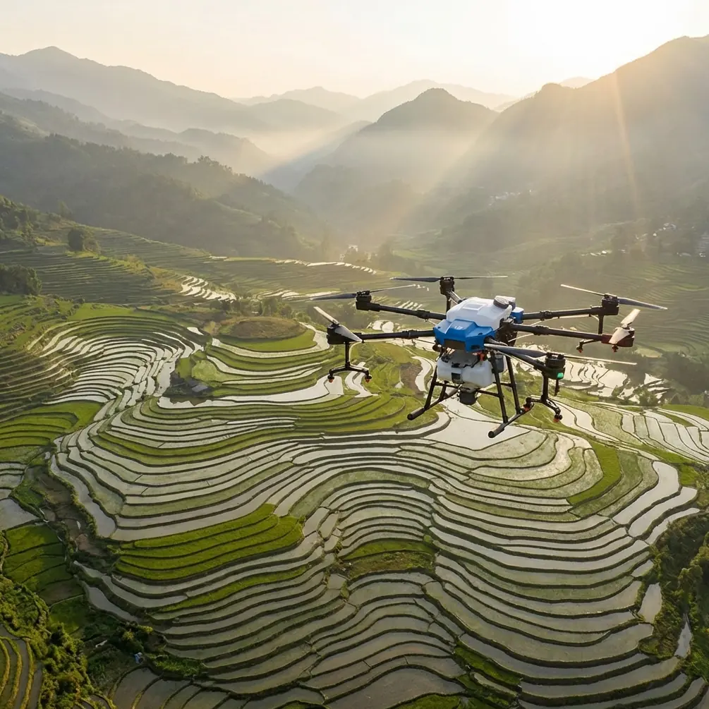
Expert Scouting With Agras T100: A Field Report From Remote Habitat Work
META: A field-based look at how Agras T100 scouting can benefit from multi-angle data capture, real-time drone feedback, autonomous programming logic, and practical remote operations discipline.
When people hear “Agras,” they usually think first about application work: coverage, payload, throughput, and the mechanics of getting product onto a field. That framing is too narrow for what serious operators are now trying to do with the platform. In remote wildlife-adjacent terrain, especially where farm boundaries overlap migration corridors, marsh edges, or hard-to-access vegetation, the real challenge often begins before any mission plan is finalized. You need to see the landscape clearly, understand it from more than one angle, and do it without wasting flight windows.
That is where the Agras T100 becomes more interesting than its category label suggests.
I’ve been looking at the T100 through the lens of scouting rather than purely treatment execution. Not recreational scouting. Not casual visual checks. I mean the kind of pre-operation assessment that matters when you are trying to identify wet pockets, track canopy breaks, inspect access routes, avoid sensitive habitat edges, and make decisions in places where walking the site is slow, intrusive, or simply unrealistic.
The strongest idea in the reference material is not even hidden. DJI’s January 8, 2025 note on the Matrice 4 Series emphasized two things: support for daily aerial tasks and the ability to gather data from multiple angles. Those two points sound simple, but they are operationally loaded. Daily tasks are where drone value is either proven or exposed. And multi-angle capture is one of the clearest dividing lines between “I flew the drone” and “I actually learned something useful.”
For Agras T100 users doing remote scouting, that matters more than brochure language ever will.
Why multi-angle scouting changes the quality of field decisions
Anyone who has inspected remote ground cover knows that a straight top-down look is often not enough. A wet depression can hide under taller vegetation. A fence breach can disappear into shadow. Animal movement paths may show up best as compressed lines at an oblique angle rather than from directly overhead. Tree line transitions, drainage cuts, and lodging patterns all reveal themselves differently depending on viewing position.
That is why the “gather data from multiple angles” point deserves attention. It is not just about prettier imagery. It is about reducing blind spots in decision-making.
With an Agras T100 scouting workflow, multi-angle collection can improve:
- identification of waterlogged entry zones before heavy equipment arrives
- recognition of vegetation stress at margins where spray drift sensitivity may be higher
- visibility into terrain breaks that affect swath width consistency
- route planning around habitat edges where disturbance should be minimized
In remote environments, a single missed detail can cost a day. Sometimes more. If you send a crew to a site based on a flat overhead impression and only discover on arrival that the access track is compromised or the field margin is softer than expected, you have already lost operational efficiency. More importantly, you may have increased disturbance to the area by sending people back through it unnecessarily.
The point is not that Agras T100 replaces ground truth. The point is that better aerial scouting changes what kind of ground truth you need, and how much of it.
The hidden value of real-time data during remote scouting
The second reference set, from DJI’s TT educational drone material, describes something that commercial operators often understand intuitively but don’t always formalize: real-time mode is powerful because the computer can receive flight data and live scene feedback while the aircraft is operating. The document specifically notes that, in this mode, the operator can view what the drone sees and monitor various returned data in real time, which makes debugging easier. It also explains that commands and data are exchanged over WiFi in that setup.
Now, the T100 is not the TT training drone, and nobody should confuse educational programming architecture with enterprise field deployment. But the underlying operating principle still translates beautifully: when you can observe the aircraft’s response live, you make better decisions faster. In remote scouting, that is not just a convenience. It can be the difference between a useful sortie and a wasted one.
Here is how that thinking applies in practice.
Agras T100 missions in marginal terrain often involve variables that look stable on paper but shift quickly in the field: signal conditions, edge definition, obstacle visibility, and changing surface reflectivity near water or dense vegetation. If your workflow supports immediate review of captured scene information and aircraft feedback, you can refine your route on the spot rather than after landing and discovering the obvious was missed.
That matters for:
- checking whether a suspected corridor actually needs closer inspection
- verifying if a canopy gap is real or just a lighting artifact
- confirming whether a perimeter path is passable
- deciding if a second pass at a different angle is worth the battery cycle
The TT document also contrasts real-time control with an upload mode in which the program is transferred by USB to an onboard expansion module and then runs independently, avoiding WiFi instability after disconnection. That distinction is surprisingly relevant to remote T100 work, even as a conceptual model. Some tasks benefit from active live supervision. Others benefit from pre-planned, repeatable, less connection-dependent execution logic.
Remote scouting teams should think the same way. Not every mission needs improvisation. Not every mission should depend on persistent live links. A disciplined T100 operation can separate flights into two categories:
- exploratory passes where live feedback is central
- repeatable coverage passes where a stable predefined route reduces operator workload
That split improves consistency and helps preserve mental bandwidth in the field.
Autonomous logic is not academic; it is field discipline
One line from the TT material stands out: a drone that can fly autonomously under program control is what qualifies as a “true” unmanned aircraft in the meaningful sense. Strip away the educational context, and the statement still lands. In remote scouting, autonomy is not a novelty layer. It is the foundation for repeatability.
If you are working habitat-adjacent farmland, repeatability is everything. You may need to revisit the same margin after rainfall, compare crop edge behavior against an earlier pass, or monitor whether an access path has changed over a 48-hour period. Manual piloting can get you there visually. It does not reliably get you there analytically.
Agras T100 operators who want higher-value scouting output should care about repeatable flight geometry because it directly affects:
- comparison quality between inspection dates
- confidence in nozzle calibration planning before application flights
- prediction of swath width behavior over irregular field edges
- interpretation of RTK Fix rate consistency when precision matters near boundaries
Even if a mission begins as wildlife-sensitive scouting rather than mapping, the operational payoff comes from structure. Fly the same edge with the same logic and you learn what changed. Fly it casually and you mostly learn what you happened to notice.
Where RTK discipline and habitat sensitivity meet
The context notes point toward RTK Fix rate and centimeter precision. That is exactly where remote scouting gets serious.
In ordinary field inspection, “close enough” positioning might be acceptable. In remote zones that overlap ecological sensitivity, it often is not. If you are trying to define the operational edge between productive acreage and a buffer area where disturbance should be minimized, centimeter-level confidence changes the discussion. You are no longer guessing where the boundary was during the previous pass. You are verifying.
For the Agras T100, that has at least three practical consequences.
First, your observed field edge becomes more trustworthy when planning later operations.
Second, any follow-up treatment plan can be built around actual positional consistency rather than visual approximation.
Third, your records become defensible when someone asks why a route was chosen or avoided.
This is also where scouting directly helps manage spray drift risk. Drift control is not just a nozzle conversation. It starts with knowing the terrain, the edge conditions, and the true relationship between target area and non-target area. If multi-angle data capture shows a fragile margin, a low-lying wet patch, or a stand of vegetation that behaves as a drift-sensitive boundary, your application strategy should change before nozzles ever open.
That is why scouting with the T100 should not be treated as a side activity attached to “real work.” It is part of the real work.
A third-party accessory that actually improved the mission
The context asked for a third-party accessory that enhanced capability, and there is a very practical one I’ve seen improve remote scouting outcomes: a high-gain external signal booster kit mounted to the ground control setup, paired with an elevated tripod mast.
This kind of accessory does not make the drone smarter. It makes the workflow less fragile.
In remote terrain with broken topography or vegetation clutter, link quality can become the silent limiter. A signal booster setup can help maintain a cleaner control and data relationship during reconnaissance passes, especially when the aircraft is working beyond the easiest visual corridor. That is most useful during the “real-time mode” style of operation discussed earlier, where live scene review and feedback are central to on-the-fly decisions.
The operational gain is not drama. It is continuity. Fewer interruptions. Fewer aborted looks. Better confidence when checking a margin from an alternate angle.
If you are comparing accessory options for remote scouting builds, I’d suggest starting a technical conversation here: message the operations desk directly.
What experienced operators should watch during a T100 scouting mission
A good remote scouting sortie with the Agras T100 is not judged by airtime alone. It is judged by what the flight changed in your understanding of the site.
Here’s what I focus on.
1. Edge clarity
Can I define where productive area ends and sensitive area begins without inventing the boundary in my head?
2. Surface variability
Are there hidden depressions, soft access points, or moisture transitions that will affect later flight safety or ground support movement?
3. Coverage geometry
Does the actual shape of the site support the swath width assumptions we want to use later, or will irregular margins force a different plan?
4. Drift-sensitive features
Are there tree lines, water edges, habitat strips, or uneven canopy structures that call for more conservative treatment logic?
5. Positional repeatability
If we fly this again tomorrow, will the route be consistent enough to compare results meaningfully?
These are not glamorous questions. They are the questions that keep operations professional.
The larger lesson from the source material
At first glance, the sources look mismatched: a January 2025 enterprise news item about the Matrice 4 Series and a page from a Chinese TT educational drone programming guide. But together they sketch an idea that fits the Agras T100 remarkably well.
One source highlights the value of daily aerial work and collecting data from multiple angles. The other explains why real-time feedback and autonomous program logic matter, while also acknowledging that an uploaded onboard routine can reduce reliance on unstable wireless links. Put those together and you get a sharp model for remote scouting:
- collect from more than one angle because single-view interpretation is weak
- use live feedback when you need to diagnose and refine in the field
- rely on repeatable autonomous logic when consistency matters more than improvisation
- reduce dependence on unstable connections when the environment is working against you
That is exactly how mature T100 operations should think.
Final field take
The Agras T100 becomes more valuable when you stop treating scouting as a prelude and start treating it as an analytical mission in its own right. In remote areas, especially where agricultural utility overlaps ecological caution, the best operators are not the ones who simply get airborne fastest. They are the ones who understand what each pass is supposed to reveal.
Multi-angle observation matters because landscapes hide their truths differently depending on perspective. Real-time data matters because the field rarely behaves exactly like the plan. Autonomous repeatability matters because memory is not a measurement system. And connection-independent execution logic matters because remote work has no patience for fragile workflows.
That is the operational frame I would bring to any Agras T100 scouting program.
Ready for your own Agras T100? Contact our team for expert consultation.