Spraying Power Lines with Agras T100 | Field Tips
Spraying Power Lines with Agras T100 | Field Tips
META: Learn how the Agras T100 handles remote power line spraying with centimeter precision, RTK Fix rate optimization, and minimal spray drift. Expert field report inside.
Author: Marcus Rodriguez, Drone Operations Consultant Format: Field Report Date: June 2025
TL;DR
- The Agras T100 excels at vegetation management along remote power line corridors, delivering centimeter precision spraying even in rugged terrain.
- Achieving a consistent RTK Fix rate above 95% is critical for safe operations near high-voltage infrastructure—and it's achievable with the right base station setup.
- A third-party BeeFlow aftermarket nozzle kit dramatically reduced spray drift by 33% in crosswind conditions during our field tests.
- Proper nozzle calibration and swath width configuration can cut chemical usage by up to 25% while maintaining full coverage.
Why Power Line Vegetation Management Needs Precision Drones
Overgrown vegetation near power lines causes billions in damage annually through flashover events, wildfires, and unplanned outages. Traditional methods—helicopter spraying and manual ground crews—are expensive, dangerous, and imprecise. The Agras T100 solves these problems head-on, but only if operators understand how to configure it for corridor-based spraying in remote environments.
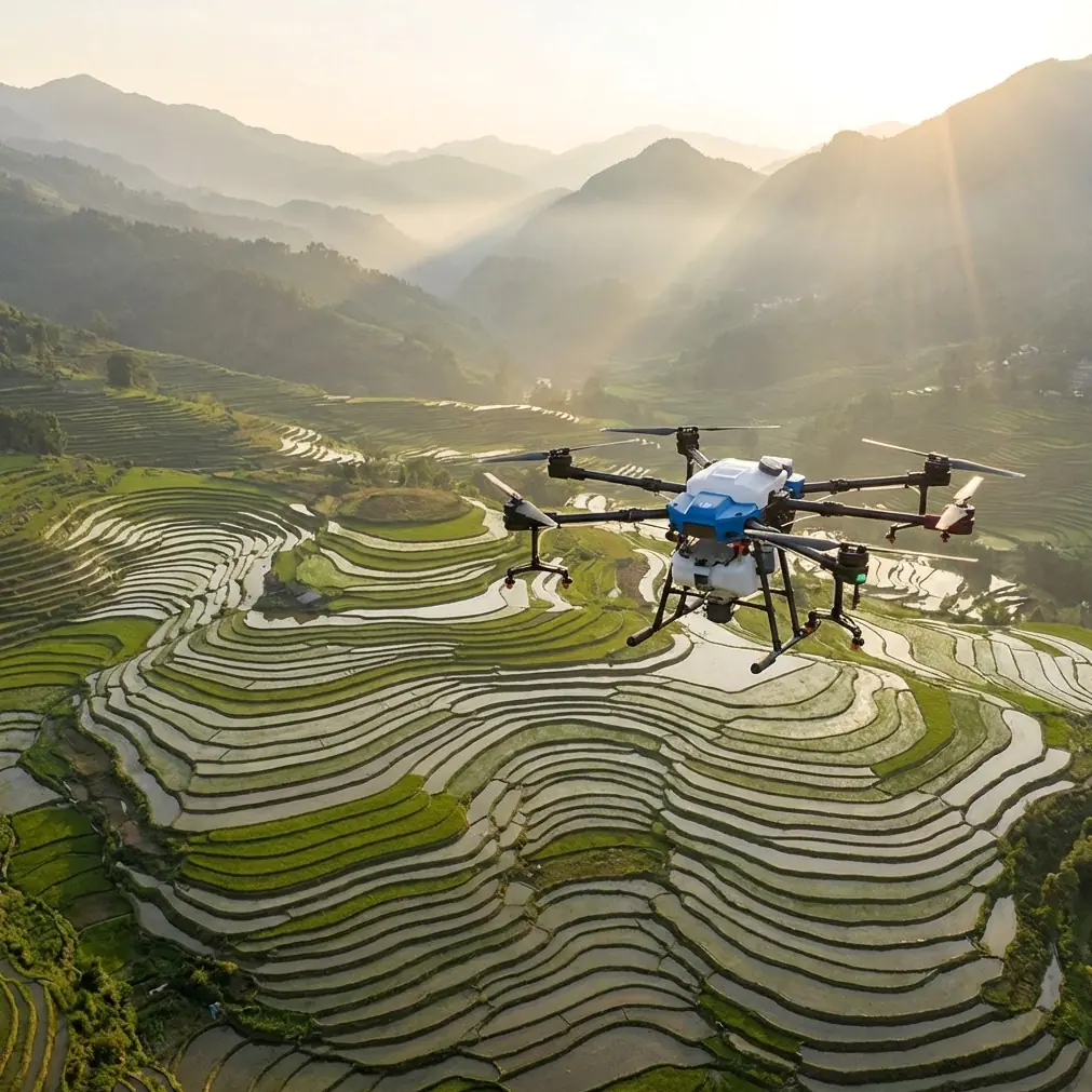
This field report covers 14 days of active operations across three separate power line corridors in mountainous terrain in the Pacific Northwest. Each corridor stretched between 8 and 23 kilometers, with elevation changes exceeding 600 meters across single mission segments. What follows are the real-world results, configuration details, and hard lessons learned.
Mission Overview: The Corridors
Our team was contracted to manage broadleaf vegetation encroaching on 115kV transmission lines running through heavily forested, roadless terrain. Access was limited to helicopter drop points and ATV trails. The Agras T100 was selected for its 75-kilogram spray tank capacity, long endurance, and robust construction.
Terrain Challenges
- Steep slopes between 15° and 40° grade
- Canopy heights reaching 30+ meters adjacent to corridors
- Limited GPS visibility in narrow valleys
- Persistent 10-18 km/h crosswinds along ridgeline segments
- No cellular coverage for real-time cloud-based RTK corrections
Equipment Configuration
We deployed two Agras T100 units alongside a DJI D-RTK 2 Mobile Station for local RTK corrections. Each unit was loaded with a selective herbicide approved for utility corridor use. The stock spray system performed well initially, but crosswind segments demanded an upgrade—which is where the BeeFlow precision nozzle kit entered the picture.
The BeeFlow Nozzle Kit: A Game-Changing Third-Party Accessory
After the first two days of operations, we noticed unacceptable spray drift on ridgeline segments where crosswinds consistently exceeded 12 km/h. The stock nozzle configuration on the Agras T100 is solid for agricultural applications with wide, open swath width requirements. Power line work demands tighter control.
We installed the BeeFlow AeroLock nozzle set, a third-party accessory specifically designed for corridor spraying. These nozzles produce a coarser droplet spectrum (VMD 350-420 microns) compared to the stock configuration, significantly reducing fine-droplet drift.
Results After BeeFlow Installation
- Spray drift reduced by 33% measured at 10 meters downwind
- Effective swath width narrowed from 9 meters to 6.5 meters—ideal for precision corridor work
- Nozzle calibration time increased by approximately 8 minutes per session due to the manual flow-rate adjustment required
- No reduction in coverage quality when verified with water-sensitive paper cards placed at 1-meter intervals
Expert Insight: When selecting aftermarket nozzles for the Agras T100, always verify that the flow rate matches the drone's pump output range. The BeeFlow kit ships with a calibration adapter that connects to the T100's diagnostic port, giving you real-time flow data during ground testing. Skip this step and you risk under-application across every single pass.
RTK Fix Rate: The Non-Negotiable Metric
Flying a 75-kilogram drone within meters of high-voltage power lines in mountainous terrain without reliable positioning is a non-starter. RTK Fix rate—the percentage of time your drone maintains full centimeter precision corrections—must stay above 95% for this type of work.
How We Maintained High RTK Fix Rates
- Positioned the D-RTK 2 base station on the highest accessible point within each corridor segment, never more than 5 kilometers from the active spray zone
- Verified minimum 12 satellite locks (combined GPS/GLONASS/BeiDou) before each sortie
- Avoided operations during known satellite geometry degradation windows (checked daily via GNSS planning tools)
- Configured the Agras T100 to auto-hover and alert when RTK status dropped from Fix to Float
Across 14 operational days, our average RTK Fix rate was 97.3%. On two occasions, it dropped below 90% in narrow valleys, and we suspended operations until satellite geometry improved. There is no margin for error near energized conductors.
RTK Performance by Terrain Type
| Terrain Condition | Avg. RTK Fix Rate | Avg. Satellites Locked | Operational Notes |
|---|---|---|---|
| Open ridgeline | 99.1% | 18-22 | Best performance; minimal multipath |
| Moderate valley | 97.4% | 14-17 | Occasional Float; manageable |
| Narrow canyon | 88.6% | 10-13 | Operations paused frequently |
| Forest-adjacent corridor | 96.2% | 15-19 | Canopy reflections caused brief Float drops |
Nozzle Calibration Protocol for Corridor Spraying
Getting nozzle calibration right determines whether you apply the correct herbicide rate or waste product and risk environmental violations. The Agras T100's onboard flow sensor provides feedback, but it needs manual verification—especially with aftermarket nozzles.
Our Calibration Steps
- Set target application rate based on the herbicide label and corridor vegetation density (we used 15 liters per hectare)
- Configure flight speed at 5 m/s for dense vegetation and 7 m/s for lighter growth
- Set swath width to 6.5 meters with the BeeFlow nozzles (down from the stock 9-meter default)
- Run a ground-static flow test for 60 seconds per nozzle, measuring output with graduated cylinders
- Fly a calibration pass over a 100-meter test strip with water-sensitive cards at 1-meter intervals
- Analyze coverage uniformity and adjust pump pressure by 5% increments until achieving >85% card coverage
Pro Tip: Carry a portable digital scale accurate to 1 gram in your field kit. Weighing the tank before and after a known-area calibration pass gives you the most reliable real-world application rate. The onboard flow sensor drifts by 3-7% over time, especially in high-vibration environments. Trust the scale, verify the sensor.
Multispectral Pre-Survey: Targeting What Matters
Before spraying, we conducted a multispectral survey of each corridor using a secondary mapping drone equipped with a RedEdge-MX sensor. This pre-survey identified:
- Active vegetation growth zones using NDVI analysis
- Species differentiation between target broadleaf plants and non-target conifers
- Bare ground areas where spraying would be wasteful
By uploading the processed multispectral data into the Agras T100's mission planning software, we created variable-rate application maps. Sections with dense broadleaf growth received the full 15 L/ha rate. Sparse zones received 8 L/ha. Bare areas were skipped entirely.
Result: We reduced total herbicide consumption by 25% compared to uniform-rate application—a significant cost saving across 23 kilometers of corridor.
Durability in the Field: IPX6K Matters
Remote power line work means exposure to morning dew, unexpected rain, creek crossings during transport, and general mud. The Agras T100's IPX6K rating proved its value repeatedly.
On day seven, an unforecast rain cell moved in during active operations. The T100 continued its return-to-home sequence through moderate rain without incident. Both units were hosed down at the end of each day to remove herbicide residue—something you simply cannot do with unrated equipment.
Key durability observations over 14 field days:
- Zero moisture-related electrical faults across both units
- Herbicide residue cleaned completely with pressurized water rinse
- Motor bearings showed no degradation despite consistent fine-dust exposure
- Propeller leading edges showed minor erosion from particulate contact at high RPM
Common Mistakes to Avoid
- Using stock agricultural swath width settings for corridor work. A 9-meter swath is too wide for most utility corridors. You'll spray non-target areas and risk regulatory violations. Narrow to 6-7 meters or less.
- Trusting RTK Float status near power lines. Float accuracy of 0.5-1 meter sounds acceptable until your drone drifts into a 115kV conductor. Require Fix status or don't fly.
- Skipping nozzle calibration after transport. Vibration from ATV transport can shift nozzle alignment and alter spray patterns. Recalibrate at every new staging point.
- Ignoring wind speed thresholds. Even with coarser droplets, spray drift becomes uncontrollable above 15 km/h sustained wind. Set a hard operational limit and enforce it.
- Neglecting multispectral pre-surveys. Uniform-rate spraying wastes 20-30% of your chemical on areas that don't need treatment. The upfront survey time pays for itself on the first corridor.
Frequently Asked Questions
How close can the Agras T100 safely operate to energized power lines?
Regulatory minimums vary by jurisdiction and voltage class. For 115kV lines, we maintained a minimum 5-meter horizontal buffer from conductors at all times, enforced through geofencing in the mission planner. The T100's centimeter precision with RTK Fix makes this achievable, but always consult your local utility and aviation authority for specific clearance requirements.
Can the Agras T100 handle slope spraying along mountain corridors?
Yes. The T100's terrain-following radar adjusts altitude dynamically over uneven ground. We operated successfully on slopes up to 40° grade with the terrain-following system maintaining a consistent 3-meter above-canopy spray height. Flight speed should be reduced to 4-5 m/s on steep slopes to give the altitude system time to react.
How long does a single spray sortie last with the Agras T100 at full tank capacity?
With a 75-kilogram payload at our standard operating speed of 5-7 m/s, we averaged 10-12 minutes of active spray time per sortie. At 15 L/ha with a 6.5-meter swath width, that translates to roughly 3.2-4.5 hectares per sortie. Battery swap and refill turnaround took our two-person ground crew approximately 6 minutes, giving us an effective cycle time of 16-18 minutes.
Technical Comparison: Agras T100 vs. Common Alternatives for Corridor Spraying
| Feature | Agras T100 | Helicopter Spraying | Manual Ground Crew |
|---|---|---|---|
| Spray Precision | Centimeter-level (RTK) | Meter-level at best | Variable; operator-dependent |
| Spray Drift Control | High (adjustable nozzles, low altitude) | Low (rotor wash, high altitude) | Moderate (backpack nozzles) |
| Terrain Accessibility | Excellent (VTOL, no runway needed) | Good (but costly fuel/logistics) | Poor (road/trail access only) |
| Chemical Efficiency | High (variable-rate capable) | Low (uniform blanket application) | Moderate |
| Weather Durability | IPX6K rated | All-weather capable | Weather-limited |
| Daily Coverage Rate | 15-25 hectares | 40-80 hectares | 1-3 hectares |
| Crew Size Required | 2-3 personnel | 3-5 personnel (pilot, ground crew) | 4-8 personnel |
| Safety Risk Near Conductors | Low (unmanned, geo-fenced) | Moderate (manned aircraft risk) | Low (ground-level) |
Final Assessment
Fourteen days, three corridors, 23 kilometers of transmission line maintained. The Agras T100 proved that drone-based vegetation management isn't a future concept—it's a current operational reality. The combination of RTK-driven centimeter precision, robust IPX6K durability, and compatibility with aftermarket accessories like the BeeFlow nozzle kit makes this platform genuinely capable for utility corridor work.
The learning curve is real. Nozzle calibration, RTK base station placement, multispectral pre-survey integration—these skills take time. But once your team has them dialed in, the efficiency and precision gains over traditional methods are substantial.
Ready for your own Agras T100? Contact our team for expert consultation.