Surveying Vineyards with Agras T100 at Altitude
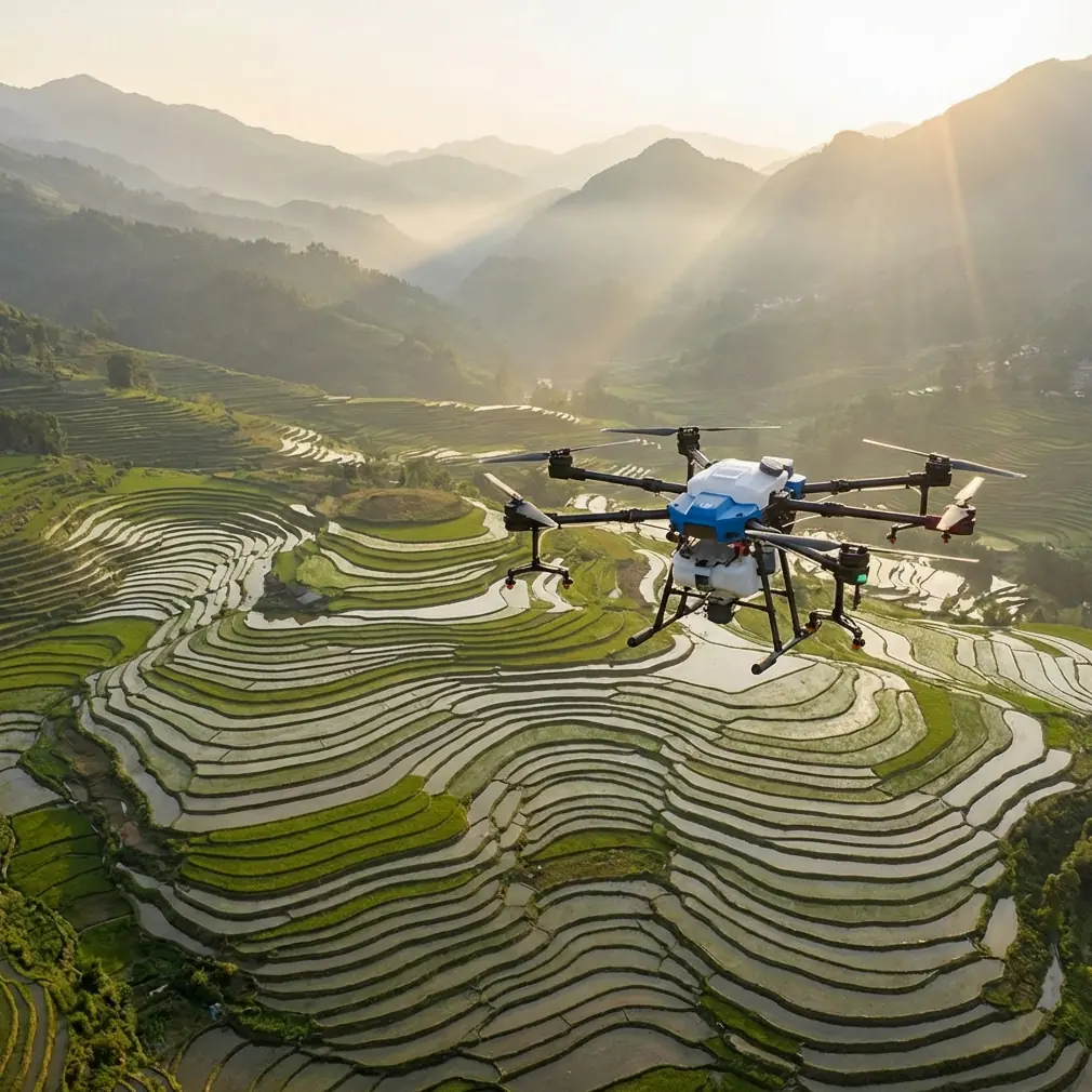
Surveying Vineyards with Agras T100 at Altitude
META: Learn how to survey high-altitude vineyards with the Agras T100. Expert tips on RTK calibration, battery management, and multispectral mapping for precision viticulture.
By Marcus Rodriguez, Agricultural Drone Consultant
TL;DR
- The Agras T100 handles high-altitude vineyard surveying with centimeter precision thanks to its advanced RTK positioning and robust airframe rated IPX6K.
- Proper nozzle calibration and swath width planning are critical when operating above 1,500 meters where thin air changes spray drift behavior and flight dynamics.
- Battery management at altitude requires a disciplined pre-conditioning protocol—cold mornings and reduced air density will cut your flight time by up to 20% if you're unprepared.
- Multispectral sensor integration transforms the Agras T100 from a spraying platform into a full vineyard health assessment tool.
Why High-Altitude Vineyards Demand a Different Approach
High-altitude vineyards—those planted above 1,000 meters in regions like Mendoza, the Douro Valley, or parts of Napa—present unique challenges that flatland operations never encounter. Thinner air reduces propeller efficiency. Temperature swings between dawn and midday can exceed 15°C. Terrain slopes often hit 30 degrees or more, turning a routine survey into a complex flight planning exercise.
The Agras T100 was engineered with these variables in mind. Its high-performance propulsion system compensates for reduced air density, and its onboard flight controller dynamically adjusts motor output to maintain stable hover and transit speeds even on steep terrain.
But the drone alone isn't enough. You need a systematic workflow to get repeatable, reliable results. That's what this guide delivers.
Step 1: Pre-Flight Planning for Mountainous Terrain
Assess the Terrain Model
Before you even charge a battery, import your vineyard's digital elevation model (DEM) into your mission planning software. The Agras T100's terrain-following mode relies on accurate elevation data to maintain a consistent above-ground-level (AGL) altitude.
For vineyards on slopes, set your AGL to 3–5 meters above the canopy. This keeps multispectral sensors within their optimal focal range while providing enough clearance for trellis systems and end-post structures.
Define Your Swath Width
Swath width directly affects coverage efficiency and data quality. At altitude, reduced air density causes the drone to work harder per meter of coverage.
- For multispectral surveying, use a swath width of 5–6 meters with 70% side overlap and 80% frontal overlap.
- For spray applications, adjust swath width based on nozzle type—typically 4–7 meters depending on your chosen configuration.
- Always run a test strip first. Conditions at 1,800 meters behave differently than conditions at sea level, and theoretical calculations need field validation.
Pro Tip: At elevations above 1,500 meters, reduce your planned swath width by 10–15% compared to lowland settings. The thinner air increases spray drift unpredictably, and a tighter swath ensures more uniform coverage on vine canopies.
Step 2: Achieving a Solid RTK Fix Rate
Centimeter precision is non-negotiable for vineyard mapping. Row spacing in premium vineyards can be as tight as 1.2 meters, and you need your flight lines to respect those boundaries exactly.
Setting Up Your RTK Base Station
- Place the base station on the highest point with a clear horizon in all directions. Mountain ridges and valley walls can block satellite signals.
- Allow a minimum convergence time of 10 minutes for the base station before launching. At altitude, ionospheric conditions can delay initial fix acquisition.
- Target an RTK fix rate above 95% throughout your mission. If the fix rate drops below this threshold, the Agras T100's positioning accuracy degrades from centimeters to decimeters—unacceptable for precision viticulture.
Troubleshooting Poor Fix Rates
| Symptom | Likely Cause | Solution |
|---|---|---|
| Fix rate below 90% | Satellite obstruction from terrain | Relocate base station to higher ground |
| Intermittent float status | Electromagnetic interference | Move base away from power lines, metal structures |
| Fix rate drops mid-mission | Drone enters shadowed valley | Plan flight path to avoid steep northern slopes |
| No fix achieved after 15 min | Incorrect base station coordinates | Re-enter known survey point or allow autonomous survey-in |
Step 3: Battery Management at Altitude—A Field-Tested Protocol
Here's where I want to share something that saved an entire season of survey work for a client in the high-altitude vineyards outside of Salta, Argentina, at roughly 1,700 meters.
We arrived at dawn for optimal lighting conditions—ideal for multispectral capture. The ambient temperature was 4°C. We loaded batteries straight from the vehicle, powered up the Agras T100, and watched the first battery drain 22% faster than expected. The drone returned with a low-battery warning after covering barely 60% of the planned block.
The problem wasn't the drone. It was battery temperature. Lithium-polymer cells lose significant capacity when cold, and altitude compounds this because nighttime temperatures at elevation drop sharply.
The Protocol That Fixed Everything
- Night storage: Keep batteries indoors or in an insulated case at 20–25°C overnight. Never leave them in a vehicle.
- Pre-heat cycle: Use the Agras T100's battery pre-conditioning feature. It warms cells to an optimal operating temperature before flight. This takes 8–12 minutes but recovers up to 18% of lost capacity.
- Rotation system: Bring at least 4 batteries for every 2 flights planned. While one pair flies and cools, the other pair pre-conditions.
- Voltage monitoring: At altitude, set your return-to-home voltage threshold 0.2V higher per cell than the manufacturer's default. The reduced air density means the motors draw more current on the return climb, and you need that buffer.
Expert Insight: I've logged over 800 vineyard flights above 1,200 meters. The single biggest predictor of mission success isn't sensor calibration or flight planning—it's battery discipline. A cold battery at altitude doesn't just reduce flight time; it changes the drone's power response curve, making terrain-following less precise and hover stability less reliable. Treat your batteries like the most critical component in the system, because they are.
Step 4: Nozzle Calibration for High-Altitude Spraying
If you're using the Agras T100 for targeted vineyard spraying between survey flights, nozzle calibration becomes altitude-dependent.
Key Adjustments
- Droplet size: At altitude, lower air density means droplets travel farther before decelerating. Increase your droplet VMD (Volume Median Diameter) by selecting a coarser nozzle setting to reduce spray drift.
- Pressure settings: Reduce operating pressure by 5–10% compared to sea-level baselines. The pressure differential between the nozzle outlet and ambient air is already greater at altitude.
- Flow rate validation: Use a calibration cup to physically measure output per nozzle per minute. Don't rely solely on software estimates—altitude changes the math.
Spray Drift Considerations
Spray drift is the silent killer of precision application at altitude. Wind patterns in mountainous vineyard regions are highly localized—thermal updrafts begin mid-morning, and katabatic winds roll downslope after sunset.
- Spray only during the early morning window (first 2–3 hours after dawn) when thermals are minimal.
- Use the Agras T100's onboard wind speed sensor to monitor real-time conditions. Abort if wind exceeds 3 m/s at canopy level.
- Set buffer zones of at least 10 meters from vineyard boundaries to prevent drift onto adjacent blocks or neighboring properties.
Step 5: Multispectral Data Collection and Integration
The Agras T100 supports multispectral sensor payloads that capture NDVI, NDRE, and thermal data critical for vineyard health assessment.
Best Practices for Altitude Operations
- Calibration panels: Place reflectance calibration panels at the start and end of each flight block. At altitude, solar irradiance is higher, and uncalibrated data will skew your vegetation indices.
- Flight speed: Maintain a consistent ground speed of 4–5 m/s for multispectral capture. Faster speeds cause motion blur in narrow-band sensors.
- Sun angle: Capture data when the solar elevation angle is between 30° and 60° to minimize shadow interference between vine rows.
Technical Comparison: Agras T100 at Altitude vs. Sea Level
| Parameter | Sea Level Performance | High Altitude (1,500m+) |
|---|---|---|
| Hover power consumption | Baseline | +12–18% increase |
| Effective flight time | 100% rated capacity | 80–85% rated capacity |
| RTK fix acquisition time | 2–5 min typical | 5–12 min typical |
| Spray drift risk | Moderate (predictable) | High (variable thermals) |
| Optimal swath width | Manufacturer default | Reduced by 10–15% |
| Battery pre-heat necessity | Optional | Mandatory below 10°C |
| IPX6K relevance | Rain protection | Rain + morning dew + frost melt |
| Multispectral calibration | Standard protocol | Enhanced protocol (higher UV) |
Common Mistakes to Avoid
- Skipping battery pre-conditioning: This is the number one cause of aborted missions at altitude. Those 8–12 minutes of warm-up pay for themselves every single flight.
- Using sea-level swath settings: Copy-pasting your flatland mission plan to a mountain vineyard guarantees uneven coverage and wasted chemicals.
- Ignoring thermal wind windows: Flying spray missions after 10:00 AM in mountain terrain means you're fighting unpredictable thermals that amplify spray drift.
- Setting RTK base station in a valley: Satellite geometry suffers dramatically when the horizon is blocked by ridgelines. Always position on the highest accessible point.
- Neglecting calibration panel placement: Multispectral data without proper radiometric calibration is essentially decorative. Place panels on flat ground within 50 meters of your launch point.
- Over-relying on automated terrain following without DEM verification: If your elevation model is outdated or inaccurate, the drone follows bad data. Ground-truth your DEM with 3–5 manual altitude checks before committing to an autonomous mission.
Frequently Asked Questions
Can the Agras T100 operate reliably above 2,000 meters?
Yes. The Agras T100's propulsion system is designed for high-altitude operation, but you must account for reduced flight time (plan for 80% of rated endurance), longer RTK convergence times, and mandatory battery pre-conditioning. Operators in regions like the Andean wine valleys routinely fly at 2,200 meters with proper protocol adherence.
How does the IPX6K rating matter for vineyard work at altitude?
High-altitude vineyards experience rapid weather changes—morning frost melt, afternoon rain squalls, and heavy dew. The IPX6K rating means the Agras T100 can withstand high-pressure water jets from any direction, so moisture from wet canopies, sudden rain, or irrigation overspray won't compromise electronics mid-mission. This is especially valuable during early-morning flights when the entire canopy is dew-soaked.
What RTK fix rate should I target for row-level precision in vineyards?
For row-level precision in vineyards with spacing under 2 meters, target an RTK fix rate of 95% or higher throughout the entire mission. This ensures centimeter precision on your flight lines, which directly translates to accurate multispectral data co-registration and precise spray placement. If your fix rate drops below 90%, land and troubleshoot before continuing—the data collected during float or single-solution status is unreliable for precision viticulture applications.
Ready for your own Agras T100? Contact our team for expert consultation.